
The Unnatural Kingdom?
March 14th, 2016
Courtesy of The New York Times, some commentary on the impact that technology has upon nature and the natural experience:
IF you ever have the good fortune to see a Sierra Nevada bighorn sheep, the experience might go like this: On a sunny morning in Yosemite National Park, you walk through alpine meadows and then up a ridge to the summit of Mount Gibbs at 12,764 feet above sea level. You unwrap a chocolate bar amid breathtaking views of mountain and desert and then you notice movement below.
Binoculars reveal three sturdy ewes perched on a wall of rock, accompanied by two lambs and a muscular ram. The sight fills you with awe and also with gratitude for the national parks, forests and, yes, environmental regulations that keep the American dream of wilderness alive.
Unless your binoculars are unusually powerful, you are unlikely to notice that many of those sheep wear collars manufactured by Lotek Wireless of Newmarket, Ontario. You will, therefore, remain unaware that GPS and satellite communications hardware affixed to those collars allows wildlife managers in distant air-conditioned rooms to track every move made by those sheep. Like similar equipment attached to California condors, pronghorn antelope, pythons, fruit bats, African wildebeest, white-tailed eagles, growling grass frogs, feral camels and countless other creatures, those collars are the only visible elements of the backlot infrastructure that now puts and keeps so many animals in the wild.
Mostly hidden from view, this infrastructure is proliferating and improving so quickly, thanks to advances in digital technology, that wildlife managers are seizing more and more of nature’s relevant dials — predator and prey alike — and turning those dials to keep nature looking the way we want it to. Undeniably in the service of good, this technological revolution in the human relationship to wildlife is also accelerating the ancient human project of bringing the physical world under our control.
In the case of the Sierra bighorn, a genetically distinct subspecies of wild sheep, there were likely more than a thousand before the 1849 gold rush brought domestic sheep into the High Sierra. Those domestic sheep carried diseases for which bighorn had no defense. In the late 1970s, a field biologist named John Wehausen counted 250 survivors, none inside Yosemite National Park. In 1979, Mr. Wehausen began a recovery effort that included translocation of sheep back into the area around Mount Gibbs, where there had once been a herd. But then a state moratorium on the sport hunting of mountain lions caused an increase in lion numbers, and some of those lions began to prey on bighorn. Then a mid-1990s drought depressed the deer population, causing even more lions to become sheep specialists. Bighorn numbers crashed, and the total population dropped to near 100. In 2000, the federal government listed the Sierra bighorn under the Endangered Species Act.
The subsequent Sierra Nevada Bighorn Sheep Recovery Program, an interagency collaboration, tacitly acknowledged that our biggest and best-protected wild ecosystems are so badly compromised that we can no longer fence them off and hope for the best. Starting in the early 2000s, the recovery program employed ancient and contemporary technology: Net-guns, fired from helicopters, were used to capture bighorn outfitted with collars that carried both GPS and VHF radio transmitters; professional hunters, meanwhile, tracked and darted every mountain lion in the area to outfit them with collars that carried VHF radio transmitters. Biologists at computer monitors began to watch bighorn movements. Anytime a lion killed multiple bighorn in a short period of time, those hunters used VHF radio telemetry and specially bred lion hounds to find and kill it.
Once bighorn herds grew large enough to spare members, biologists moved them around — to establish new herds in long-vacant habitat and to inject biological diversity into smaller herds like the one on Mount Gibbs. This was done through operations that read like science fiction about humans trapped in a game reserve managed by alien overlords.
In March 2013, according to Tom Stephenson, the program director, a fixed-wing aircraft circled above an established herd on Mount Langley, a 14,026-foot peak. Technicians onboard that airplane used radio telemetry to guide a low-flying Hughes 500 helicopter toward five pregnant female sheep known from previous DNA testing to carry diverse genetics. The helicopter herded the pregnant sheep up a mountainside. A man leaned from the helicopter and fired a net gun that tangled up one female after another. Another man, known as a “mugger,” jumped out and tackled the netted females, hobbled and blindfolded them, and then wrapped them in bags that dangled from the underside of the helicopter.
The sheep were flown to a parking lot for blood draws that allowed disease testing and more DNA-sequencing, as well as ultrasound testing for body-fat analysis and skeletal measurements of their fetuses. Next, they were trucked some 100 miles north, transferred into bags hanging below another helicopter, flown up near Mount Gibbs and freed to give birth among sheep they’d never met.
The view through those binoculars, in other words, lovely as it might be, will also be a deeply human cultural product. People have always manipulated the natural world. The most primitive farms are human-managed ecosystems; European aristocrats fenced off game reserves in the Middle Ages; Western American land managers have argued for more than a century over how to protect livestock from predators; and government agencies have long dumped hatchery-raised trout into streams so that we can have fun catching them. Radio collars and species-recovery projects have been around for a while, too: In California alone, starting back in the 1980s, biologists saved both the peregrine falcon and the California condor from extinction.
More and more, though, as we humans devour habitat, and as hardworking biologists — thank heaven — use the best tools available to protect whatever wild creatures remain, we approach that perhaps inevitable time when every predator-prey interaction, every live birth and every death in every species supported by the terrestrial biosphere, will be monitored and manipulated by the human hive mind.
Conservation Metrics, for example, a California technology start-up, is developing software to process immense data sets — from remote camera traps or, say, DNA samplers that might one day sit in wilderness streams and filter DNA fragments as a way of counting species in a given watershed. Mark Hebblewhite, a wildlife biologist at the University of Montana, integrates real-time moisture and temperature data from satellites with data from accelerometers attached to birds’ wings to keep tabs on bird flocks in migration. Drone aircraft allow Tim Boucher, a Nature Conservancy scientist, to map wilderness terrain down to an astonishing five-centimeter resolution.
As for manipulation, African game managers use similar drones to herd wild elephants away from farms where they might get shot. A still more intriguing example comes from Western Europe, where large predators were mostly killed off by the Renaissance. Fifteen years ago, biologists in Trentino, Italy, traveled to Slovenia to capture 10 European brown bears, smaller cousins of grizzlies. These bears were released into the Italian Alps with extraordinary success; 10 bears are now 50.
“It’s exciting to have these large, iconic carnivores roaming Central Europe where they were extirpated centuries ago,” said Francesca Cagnacci, a researcher on a follow-up project.
Predictably, a few of the brown bears in Italy began to eat farmers’ chickens, tear up commercial beehives and generally wreak havoc. Wildlife managers initially responded by outfitting problem bears with collars that allowed precise mapping of their movements. Then a pilot project tested sensors placed around local farms and other temptations. These sensors detect a signal broadcast by collars attached to bears and other wildlife, and then communicate with one another in a wireless network that delivers deterrents in random patterns: bear spray fired by hidden guns, followed the next time by sirens and bright lights, and then by robotic dogs lurching out of robotic doghouses accompanied by the prerecorded sound of barking bear hounds. If all goes according to plan, the entire system — collars, sensors, deterrents — will be operational at the end of the summer.
Like most people, I would miss the un-manipulated wild if it entirely disappeared, and I like a point that Mr. Hebblewhite makes about technological breakthroughs tempting us to overestimate our own cleverness. Even with the latest digital tools, he notes, ecosystems, and specifically the challenge of restoring broken ones, remain profoundly more complex than any phenomenon or system that humans have ever mastered. “Putting astronauts into space, that was child’s play, by comparison,” he says. “The only thing rivaling an ecosystem for complexity is the human brain.”
Mr. Hebblewhite also argues that conservation success stories like the bighorn — or the return of wolves to Yellowstone — contribute to what he calls the “Lego fallacy, the idea that ecosystems are like those Lego sets where you build the Millennium Falcon and if a piece goes missing all you have to do is find a replacement and pop it back in.”
Put another way — and a vast majority of conservationists would agree — the best strategy is still just to avoid destroying habitat in the first place, and sometimes to let developed places become wild again. Take the return of wolves to Central Europe, made possible by the fact that humans no longer hunt and trap and poison them with the same dedication they once did. “All on their own, wolves found corridors to recolonize most of the Alps and Central Europe,” Ms. Cagnacci says. “They are now in Germany, Denmark and even close to Holland! It’s like: ‘What!? Wolves in Holland!’ And it happened because people left the mountains and the forests to live in cities. It was an unconscious re-wilding, and it is more successful than the bear reintroduction.”
ONCE you break something and try to put it back together, you have to decide what exactly you want the restored version to look like. If you happen to be a government agency in a democracy, that means reassembling ecosystems based on the desires of competing interest groups. In the Rockies, where grizzlies, wolves and elk support tourism and real estate values, wildlife managers who track all those animals have to contend with homeowners who don’t want the family dog ripped in half and hunters who wonder why, when it comes to eating elk, we’d want to give wolves priority over humans in picking the tastiest-looking bulls. The Sierra Nevada Bighorn Sheep Recovery Program eventually had to stop killing mountain lions because too many Californians hated the idea of government hunters shooting those beautiful cats, regardless of the benefit to bighorn sheep. Decisions like these, based on public opinion, might someday dictate the subtlest interactions between animals everywhere.
Still, surveillance and manipulation of the wild sure beats doing nothing, especially when technology can make conservation easier. Take the recording devices that have become the spyware of the backcountry. As recently as a few years ago, researchers trying to count great gray owls in Yosemite had to hike into the forest, hoot, wait for response hoots from actual owls, and do their best to tell those owls apart. Now the same researchers can set out sensors that record every noise in the forest. Computers then crunch this data (a week’s worth runs to a jaw-dropping 23 terabytes) and identify the voices of distinct owls. Machine-learning software may soon make this easier by identifying the sound, say, of a particular female owl responding to a particular male bringing food to the nest, or of a juvenile begging for food, either of which would indicate the presence of a nesting pair.
Remote cameras have also proliferated in wilderness backcountry and these, too, are a big help to wildlife conservation. In January 2015, for example, the field biologists Stephanie Eyes and Toren Johnson snowshoed out to retrieve the memory card from a motion-sensor camera in an obscure corner of Yosemite. According to Sarah Stock, a Yosemite biologist, that camera had been baited with scent tucked into a white athletic sock nailed to a tree, part of an effort to lure and identify rare high-altitude carnivores like pine martens and wolverines.
THE pair pitched their tent, crawled in, plugged that memory card into a small hand-held camera, and saw images of the first Sierra Nevada red fox known to have entered Yosemite National Park since 1916, when a ranger killed the last one documented there. This recent sighting prompted a petition to the federal government to list the so-called greater Yosemite population of the Sierra Nevada red fox as threatened. That, in turn, set in motion a recovery effort in the park, directed by Ms. Stock, that has already deployed more cameras. With luck, these cat-size canids might become a common sight along Yosemite’s trails.
Then there is the tantalizing possibility raised by the GPS satellite that picked up a signal from the collar of gray wolf OR-7 as he wandered from Oregon into California in 2011. There had not been a wolf sighting in California since 1924, so OR-7’s walkabout — and the fact that he wore a collar — was responsible for the listing of gray wolves as a California Endangered Species. OR-7 eventually meandered back to Oregon to start a family. He is now the breeding male of the so-called Rogue Pack in Southern Oregon. Just last year, however, a wildlife surveillance camera picked up images of a different wolf pack in Northern California. That discovery led to the development of plans for protecting the pack and accommodating wolves elsewhere in the state, should they proliferate.
In densely populated California, as wolf numbers grow, the obvious next question will be, what about grizzly bears? Grizzlies are the California state animal, after all, featured prominently on the California state flag — despite the fact that no grizzly has been sighted in California since wolves disappeared, in 1924. Bernie Tershy, a conservation biologist at the University of California, Santa Cruz, and a co-founder of Conservation Metrics, points out that California has immense reaches of plausible grizzly habitat, public sentiment that favors wildlife conservation and a robust technology industry. If huge predatory carnivores can be made to coexist with humans anywhere, it has to be here. Unsightly collars on all those predators might well diminish the romance, but that would be a small price to pay for the pleasure of their enduring company on this earth.
“I loved working in really remote parts of the world where the wildlife was there just because it was there and no one was managing it,” says Mr. Tershy, who spent years as a field researcher. “And I love seeing bears without collars, but they’re going to have to get along in densely populated areas just like people do.”
,
Read More »Digital Earth: A Resilient World Requires Resilient Data
February 21st, 2016
Via Ensia, some commentary on the need – given the speed at which humans are altering the biosphere – for a digital resilience so as not to miss the opportunities for forecasting detrimental outcomes in time to avoid them. As the article and the underlying research paper note, global data needs will continue to grow, and will be met as the “digital Earth” expands, especially by way of real-time sensors:
If the bad news is that we’re living in a world in which resilience is more critical to survival than ever, the good news is that technology is more than ever providing the tools we need to cultivate resilience. Exciting innovations in digital data collection, analysis and visualization now allow us to track and understand human impacts at global to local scales and identify big-picture patterns and processes in ways never before possible, from the National Science Foundation’s Ocean Observatories Initiative, which measures physical, chemical, biological and geological variables throughout the depths of the ocean to theGlobal Earth Observation System of Systems, which provides petabytes of environmental data from space-borne, airborne andin situ sensors.
Indeed, we now find ourselves inhabiting a “Digital Earth” composed of technologies from satellites to wristwatches that monitor, map, model and manage virtually everything around us.
And it’s not just data for data’s sake. The same digital technologies we use to understand how the Earth works are also helping communities in very practical ways. These range from monitoring fire, drought or flooding to mapping the relevant insurance zones for such. They include tracking economic collapse or health epidemics, finding available drinking water, alerting us to temperature and precipitation changes, determining landscape vulnerability for land managers, monitoring air quality, even identifying the suitability of a position on one’s roof for installing solar panels.
The information such programs produce is precisely what we need to be able to cope with global change. But in order to use it to that end, we need to ensure it’s available to those who need it. In other words, we need to make sure the tools that allow us to gather and use this information are resilient, too. To that end, I propose a set of three principles that data generators should subscribe to and governments should adopt.
1. Share more than just data
To be of societal value, digital data must be tagged and analyzed, a practice commonly known as generating “metadata.” It also must be made available in a format that matches the user’s needs. We should not only share data openly, but also facilitate the use of data in a variety of ways. For example, temperature and precipitation data can be used not only to track or predict the effects of climate change but also to calculate how much energy is needed to cool a home or business in a specific region.
In making our data open to application by others, we need to be open about what we are doing with the data — the actual steps taken in an analysis or map preparation (aka “workflows”) — so others can replicate and validate (or improve upon) our work.
We also need to provide use cases — scenarios showing how and why data were used for a particular analysis or map, with an emphasis on a practical, real-world outcome. For example, a use case might tell the story of the correct or most effective way of using a particular workflow (i.e., the actual steps taken in an analysis or preparation of a map from initiation to completion), including how the data may be used in a range of formats, devices and platforms. If the reader of the use case is able to understand what is going on behind the scenes that produced a certain map or output, this will engender trust in the workflow and hence the results
2. Tell stories
Decades of studies in psychology have repeatedly shown how story affects the human mind and influences attitudes, fears, hopes and values. Storytelling is a valuable tool for taking the knowledge developed within academia and transmitting it into mainstream society in ways that resonate and empower action.
Scientists tend to want to explain how the world works by way of copious background information, overview of prior studies, detailed methods, results and discussion before getting to the take-home message. But policy-makers, journalists and the general public want the take-home message first. Telling stories is one way scientists could meet this need.
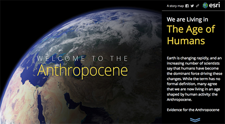
In the realm of digital data and information, a relatively new medium called the “story map” offers valuable assistance in telling a specific and compelling story. A story map allows scientists to share not only data, but also photos, videos and even sounds, all within the framework of a digital map. Story maps are created with Web map applications that provide the user with sophisticated cartographic functionality that does not require advanced training in cartography or geographic information systems, usually coupled with data needed to tell the story. Users can also leverage their own data (including workflows and use cases) in new ways to inform, educate and inspire decision-makers on a wide variety of issues.
The illustration below shows the opening page of a Smithsonian Institution story map depicting human influence on our planet and innovations that are helping to promote sustainability.
3. Be open to partnerships
Climate science, resilience studies and ecology are squarely in the realm of academia and government agencies, but it’s critical to partner with industry as well. The private sector is often looking to create and share knowledge toward solving environmental challenges in partnership with academia or government. Many companies are entering into a culture of resilience not only as part of their values or worldview, but also because it is good business.
Public–private partnerships are most successful when based on a holistic strategy that addresses specific community needs. For example, in June 2013, President Obama announced the Climate Data Initiative, which encourages innovators from the private sector and the general public to share data on climate change risks and impacts in compelling and useful ways that help citizens, businesses and communities make smart choices in the face of climate change. Similarly, NOAA has created cooperative research and development agreements with Amazon, Microsoft, Google, IBM and the Open Commons Consortium. These industry partners in turn share data with smaller companies such as AccuWeather, Esri (where I work) and PlanetOS to extend the public–private partnership even further. On a smaller scale, the new Research Data Alliance is fostering public-private partnerships to enhance data use, data quality and the adoption of data-sharing approaches and tools.
Communities around the world face increasing challenges from natural and manmade disasters. Whether they face drought or flooding, economic collapse or epidemic, communities need digital information technologies to prepare ahead of time, to operate effectively during events and to recover quickly. For digital technologies to meet this need, they too must be resilient. By sharing workflows and use cases, telling compelling stories, and building private-sector partnerships, we can help ensure that digital resources are able to provide the information we need to effectively respond to challenges wherever and whenever they arise.
,
Read More »How Mobile Telephony Can Help Lead To Climate Resistance
February 18th, 2016
Via GSMA, an interesting look at how mobile telephony can help smallholder farmers become more climate resilient:
What’s the weather going to be like tomorrow? For most of us, this is a simple question for which the answer can be found at the tip of our fingertips. For the vast rural population in the developing world, the answer isn’t as straightforward. In fact, for the majority of the 2 billion people depending on rain-fed agriculture for their livelihood, access to accurate, localised weather forecasts is a challenge.
We’ve just released a new report that shows how mobile can contribute to improving weather forecasting and monitoring in developing countries. The paper also shows how weather information can help mobile operators and VAS providers evolve the value proposition for agricultural value added services (Agri VAS), increasing the opportunity for scalability and impact of their services.
In the developing world, weather forecasts are predominantly disseminated via traditional media outlets such as TVs and radios. These channels are not easily accessible by all, especially for farmers out in the field who need to time their activities to catch weather updates. Receiving information on weather forecasts is critical for agricultural workers to organise their farming practices, especially in tropical areas where weather patterns can vary largely within short distances. Additionally, the need for weather information is exacerbated by the unpredictable changes of weather patterns in the last decades and its impact on global food supply [1].
Alongside market price information and agronomic advice, weather forecasts are a typical component of mAgri services. However, through our research we’ve identified two main challenges hindering the full value potential weather service information can deliver. These are:
- The source of weather information is often limited to national government agencies with low capacity and obsolete technologies for provision of localised weather data (at best available at a regional and district level);
- Weather content remains generic and static providing little value to the users who look for frequent meteorological updates.
As the most ubiquitous ICT tool in developing countries, we argue that mobile is uniquely positioned to address these challenges. In fact, MNOs and VAS providers can and should invest in providing highly localised, possibly farm-level forecasts with actionable content to improve their overall Agri VAS offering. For farmers, the added value of accessing weather forecasts on their mobile and having information customised and localised to their needs could be very high.
The increasing adoption rate of smartphones with GPS capabilities is offering a technology-based solution to the challenge of localisation, but not for everyone. For the vast majority of the rural population who don’t have access to data services, Agri VAS that include weather forecasts delivered via voice and text channels and over 2G networks are still a need. In this respect, the mobile industry is able to leverage the following capacities:
- In the absence of GPS, low cost location based services (LBS) that leverage existing network intelligence (Cell ID and triangulation techniques) can provide location information needed for relevant weather forecasts (see sub chapter: ‘Creating value of geo location’ page. 12).
- To improve the quality of weather content information, MNOs can form new partnerships with alternative data providers, other than national meteorological agencies. Ignitia, aWhereand Foreca are a few examples of weather data service provider with modelling techniques offering high resolution and localised weather forecasts. In recent years, free and open data initiatives for weather and agriculture have also emerged as another source of weather forecasts (see sub chapter: ‘Improving weather forecasts in Agri VAS’ page. 10)
Exploiting the full value potential of weather information would mean placing weather forecasts at the core of the Agri VAS value proposition rather than an additional component of the service. There is an emerging opportunity for mobile to improve the weather information by linking forecasts to agronomic advice on how to react to these weather conditions.
Paired with its localisation ability, mobile’s unique capability to customise services to the individual user presents an opportunity to evolve the value proposition to weather adaptive models. In fact, as weather patterns threaten to worsen and affect global food supply, mobile can become the ICT tool helping smallholder farmers in developing countries become more resilient to these climate changes. (see chapter: ‘Evolution to weather adaptive and climate smart services’ page. 16)
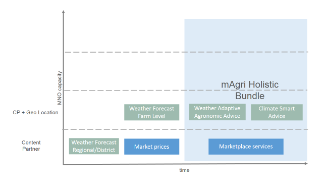
Figure 1 – Evolution to mAgri holistic bundles
In sum, the report shows that the mobile industry can play a key role not only in disseminating weather forecasts but also in improving weather services by catalysing new content and technology providers. By increasing their focus on weather services, MNOs can evolve the value proposition of their rural services towards more holistic bundles including agronomic advice linked to localised weather forecasts and climate smart agronomic advice. In the next entry we will outline how these bundles can also provide a gateway to mobile money enabled agricultural financial services promoting rural financial inclusion.
,
Read More »The Surprising Link Between Mountain Gorillas And iPhones
February 18th, 2016
Via Ozy, an interesting look at the surprising link between mountain gorillas and iPhones:
Deep inside the misty, muddy jungle of Volcanoes National Park, elusive forest elephants, buffalo and hyenas roam around, foraging for food in the cool mountain air. A group of Rwandans in army-green fatigues crouch down, too, nestled among the bushes, observing a troop of mountain gorillas. They’re not guarding the animals, or chasing poachers. Nor are they taking a work break to revel in the natural glory all around them.
No, they’re counting.
It’s part of a massive undertaking: Seventy rangers, zoologists and local guides are trying to count every living mountain gorilla. You’d think it would have been done by now — aren’t we always hearing alarmingly low figures on various threatened animal populations? But in the past, determining hard-and-fast numbers on the mountain-gorilla population was nearly impossible.
The rangers invited him along to the scene of the crime deep in the bush, where they found a rhino with her “face chopped out” and a baby rhino, terrified, protecting her mother.
Welcome to a new, futuristic era of animal conservation, where wildlife tech — in this case, high-end iPhone-style trackers — is being used to track and help save our favorite creatures, whether on land, in the air or in the sea. Technological innovation is replacing the old image of a lone field biologist carrying binoculars and a notebook with things like rangers in Kenya using drones to fight poaching in 52 game parks. You can thank the little computers in every scientist’s pocket, which make it easier to do things like send text messages from the collars of Kenyan elephants to rangers when problem pachyderms come near fields, so the animals won’t get shot and the villagers can still eat. It’s making crime-fighting citizen science a reality, with apps like WildScan in Thailand and Vietnam that let people identify and report the sale of more than 300 illegal pets, from a Southeast Asian box turtle to a pygmy slow loris (we’re looking at you, Rihanna).
Sophisticated criminal networks make big bucks from wildlife trafficking and killing animals like elephants, rhinos and tigers — an industry worth up to $10 billion a year, according to the World Wildlife Fund. That ranks it as the fourth-biggest illicit industry behind drug, human and fake goods trafficking. But wildlife tech is fighting back. Ralph Clark, CEO of ShotSpotter, was in South Africa’s Kruger National Park when the system, which pinpoints gunfire coordinates and alerts rangers within 30 seconds, detected gunshots. Poachers were on the hunt. The rangers invited him along to the scene of the crime deep in the bush, where they found a rhino with her “face chopped out” and a baby rhino, terrified, protecting her mother. Though the poachers got to the mom, the park rangers were able to save the baby, which would have otherwise died without her mother. Sadly, this rhino was one of 1,215 killed in South Africa in 2014.
Conservationist and founder of Mongabay Rhett Butler says it’s remarkable how reluctant most wildlife biologists were to veer from more traditional uses of tech in the field, like camera traps or tagging. There’s been a disconnect between tech engineers and the jungles of Southeast Asia, or the Kalahari Desert in southern Africa, but now cheaper and more prevalent gadgets — not to mention easier-to-grab data from satellites and the cloud — make it more accessible and compelling. This trend is linking together biologists, NGOs, government agencies and techies who want to stop crime, for the sake of the animals and because it’s been said to finance things like terrorism and sex trafficking. ShotSpotter’s original purpose, for example, was to detect and alert police of gunfire in 90 cities across the U.S. Even the U.S. government is trying to translate tech to the conservation context, with a $500,000 contest for innovative ideas to bust the bad guys.
Part of fighting poaching means tracking populations. When rangers know precisely how many gorillas or rhinos live in an area, they are aware when one goes missing. And with polished figures comes better data for scientists and more accurate conservation policies, which can mean bigger animal populations and more tourism, which can equal more money. It’s like an exponentially positive chain reaction. In places like Rwanda, more gorillas has meant far more money. The gorillas had more than 20,000 visitors in 2014, a threefold increase in 11 years, according to government figures.
It’s a fascinating story, not just about tech, or nature, or the economy, but also about the interconnectedness of it all. Most governments, particularly cash-strapped ones, are not going to conserve wildlife for ethical reasons. But if they see a way for the wildlife to bring in revenue — more gorillas, more money — it’s a different ball game. And every week it seems that iPhone-size technology has new applications.
But some tech toys can do more harm than good in the wrong hands. South African rangers are reluctant to reveal how or where they arrest would-be poachers when the ShotSpotter system is in play because it might reveal the location of the system, which would defeat the whole purpose. The ShotSpotter system underwent a camouflage makeover so poachers can’t find and disassemble it. There’s also the very real issue of corruption — its second shot ever captured, for example, uncovered an inside poaching job. There’s no point in having a detection system if park employees are passing along information. The fear of this has bigger consequences, too. Big-budget buyers like the U.S. Department of Defense are happy to keep tech prices artificially high to keep the gadgets in the “right” hands.
Then there’s the unsexy side of tech in the field. A lot of what’s useful inSilicon Valley simply doesn’t translate to rural areas or match on-the-ground realities — like harsh environments or local perceptions. There are “concerns about rich Westerners using drones to essentially spy on poor communities who may be poaching,” says Butler. Or using technology that doesn’t seek biologist input first. White rhinos, for one, can wear certain collars just fine, but put the same thing on a black rhino and it will rub its ears off. “The reality is … a lot of money can be wasted,” says Eric Dinerstein, director of WildTech at Resolve.
The last big hurdle is something we take for granted: cell connectivity. Conservationists hope the Facebooks and Googles of the world will have success with their Internet airplanes and other futuristic projects aimed at connecting the developing world (where most threatened species live). Because all the tech on the planet won’t make a difference if you can’t actually call for backup when you know where a poacher is.
,
Read More »Wired In The Wild
December 23rd, 2015
Via GreenBiz, an article on five lessons from the field of technology and conservation:
What do you get when data scientists, imagery experts and sensor advocates mingle with conservation specialists? A gathering that looks a lot like this year’s World Wildlife Fund Fuller Symposium, appropriately themed “Wired in the Wild.”
The “big” question addressed by this year’s speakers: “Can technology save the planet?” The qualified answer: it will play an essential and increasingly inevitable role, with the right human intervention. “Environmental science depends on software and data,” noted Victoria Espinel, president and CEO of tech trade group BSA, the Software Alliance, in her keynote remarks.
That innovation comes in many shapes — from satellite imagery that helps detect illegal logging to the Internet of “living things” that is being used to catalog bird, mammal and fish migratory patterns. “Imagery is great as a tool to show people things they would not otherwise be able to see,” said John Amos, president of SkyTruth, an organization that has used satellites to track everything from oil spills to mountaintop strip mining.
As a moderator for this year’s symposium, I was granted a front-row view into some of these compelling experiments. Here are some of my takeaways from this extraordinary conference, which took place in November at the National Geographic headquarters in Washington, D.C.
1. Collaboration is crucial
Certainly, the goal of an individual wildlife or habitat research project is very local in nature. Literally. Still, scientists could benefit from sharing best practices about how to use specific technologies — a theme that emerged time and again during the Fuller Symposium presentations.
Sharing is the mission behind a new online community, Wildlabs.net, launched in mid-November by an alliance of influential conservation organizations with the support of Google and chip designer ARM — and trumpeted loudly during the conference.
“By bringing together experts from multiple sectors, we can create solutions to challenges that have proven impossible to solve in isolation,” said Ian Ferguson, vice president of worldwide marketing and strategic alliances for ARM. “Whether that is by enabling communities to apply new tools in protecting their natural resources, transforming our understanding of wildlife and natural systems through tracking and listening technologies, or supporting the detection and prevention of poaching in protected areas, technology can be a powerful tool for the conservation cause.”
The organizations participating in Wildlabs are Conservation International, Fauna & Flora International, International Union for Conservation of Nature, Nature Conservancy, Wildlife Conservation Society, WWF, Zoological Society of London and the Royal Foundation.
2. Community participation matters
Many of the most successful projects discussed during this year’s Fuller Symposium shared this trait: the organizing researchers worked closely with members of the local community to encourage participation.
One example comes from Uganda, where wildlife veterinarian and game warden Margaret Driciru counts on local rangers to submit data about injured or dead animals they find throughout the countries parks and preserves. The intention is to minimize human and wildlife conflicts. By asking rangers to watch for signs, Driciru was able to educate a broader part of the community about the issue.
Google Labs product lead Katharine Chou offers another illustration, from her work with the Lewa Wildlife Conservancy in northern Kenya. The organization uses tracking technology and Google’s StreetView mapping software to follow the migratory routes of several endangered species, including elephants. The data uncovered by this initiative inspired the creation of a “throughway” that opens up the animals’ traditional migratory route, while allowing humans to traverse the habitat. “We’re helping reroute animals before there is a conflict,” Chou said.
3. Keep an open mind
Any researcher using technology — anything from sensors and wireless communications to specimen-collection equipment — should expect many humbling false starts.
Consider the story of National Geographic David Gruber, a pioneer in deep ocean exploration. Gruber recalls his early expeditions in an “exosuit,” a $600,000 metal suit that looks much like what astronauts use for space exploration.
While Gruber expected the 530-pound suit to make sample collection at depths of up to 1,000 feet simpler, his preference now is for a small bubble-like submarine, which makes it easier for divers to see much more of the ocean’s floor. “My whole view on what the deep sea is like changed in a minute,” he said.
Gruber’s early missions also revealed a shortcoming in the design of the collection arms: The traditional claws were tough on delicate specimens. Now the team is experimenting with a design that mimics an octopus tentacle, strong yet gentle. Far more appropriate for gathering objects from the ocean floor.
4. Consider the ethics of collecting data carefully
Time and again, the Fuller Symposium speakers pointed up the need for more education about how much conservation data should be shared publicly — and what should be secured to protect vulnerable animals. Key goals should be accurate and accessible information, collected in the most non-intrusive way possible.
“We need to responsibly unleash data in an appropriate way,” said D.J. Patil, America’s chief data scientist and head of the White House Office of Science and Technology Policy.
Contrary to what many people believe, Microsoft Research scientist Lucas Joppa suggests the conservation community suffers from a lack of information — many databases aren’t being kept up to date with real-time information, he noted.
On the other hand, social networks such as Facebook reach almost 20 percent of the world’s connected population. More attention must be paid to bridging this divide. “How do we use the information age to counter the impact of the anthropecene?” Joppa asked the Fuller Symposium attendees rhetorically.
5. Don’t underestimate the role of the private sector
A who’s-who list of software companies — ranging from Autodesk to Google to IBM to Microsoft— is contributing intellectual property to conservation projects, several of which were mentioned during symposium presentations. Autodesk’s software, for example, is being used to capture and create highly detailed 3-D images of how coral reefs off the Hawaii island of Molokai are changing over time.
Google’s outreach is well-documented: close to 200 WWF projects are visualized through the Google Earth’s mapping service. This is allowing scientists, students and citizens unprecedented access to information about habitats, and endangered and invasive species.
Environmental scientist Jack Dangermond is driving a similar crusade in “spatial literacy” with his company Environmental Systems Research Institute (Esri). Schools are a major focus.
“If you look at the future of the world, it doesn’t look so good,” Dangermond told GreenBiz in November 2014. “Kids are not understanding all the patterns and relationships of climate change or urbanization or population growth. This is a way to get them to understand those parameters, in a do-it-yourself, learn by doing, project-based learning environment. Teachers love this. The kids go crazy, when you see them, if they have a good teacher.”
For his part, Patil underscores the role of private sector involvement in advancing conservation that the public sector can’t afford to fund on its own. “People are combining data in very innovative ways,” he said during the symposium. “It’s not a debate, it’s tangible.”
,
Read More »Conservation Technology
December 19th, 2015
Courtesy of The Wall Street Journal, an interesting article on conservation technologist Shah Selbe’s use of data and drones to protect the planet:
Mr. Selbe, a Jacques Cousteau fan who grew up snorkeling and scuba-diving near Riverside, Calif., was looking for innovative ways to use technology to protect the planet. That is what he’s been doing ever since—while keeping his rocket-science day job at Boeing, which hired him straight out of college.
A self-described “conservation technologist,” Mr. Selbe, 33, combines mobile technology, satellite data and drones to better protect the environment. Used together, “these devices can watch over areas in ways that no single person could ever do,” he says.
As a graduate student at Stanford University, Mr. Selbe created an open-source, low-cost platform to pull data from satellites, drones and other monitoring systems to help identify illegal and unregulated fishing in the world’s oceans—a problem that preoccupies conservationists, who warn that overfishing could lead to a crash in world-wide fish stocks in the next three decades.
Mr. Selbe has developed a similar open-source system to monitor illegal wildlife trafficking and threats to water and air quality in Botswana’s Okavango Delta. “We want it to be open-source and used by the most people who can,” he says. “There’s a lot we gain by sharing information.” Starting last year, with support from the National Geographic Society (whose magazine employed me until 2014), Mr. Selbe worked with colleagues to set up hubs in the region, outfitted with solar-powered sensor platforms to gather data and rush details to communities on the ground via cellular networks.
The system has pinpointed problems at the local level. In one area of the Okavango Delta, data earlier this year indicated sudden, conspicuous changes in the water’s pH. “I thought the sensor was off,” Mr. Selbe says. It wasn’t: Tour boats were idling in that part of the delta, with their engines spewing toxins, making pollution concentrate in the water. Mr. Selbe and his team worked with the boat drivers to find better places to park and discouraged them from letting engines idle, letting the water quality return to normal.
In separate projects, Mr. Selbe has also deployed drones to patrol coastal regions and used hydrophones—underwater microphone networks—to detect noise from fishing vessels illegally entering protected ocean waters. Too often, Mr. Selbe says, those who monitor illegal fishing have had to just “jump in a boat until they see something.”In the seven years since Mr. Selbe began his conservation-technology efforts, his expertise has been tapped by the State Department, the Pew Environment Group and the Pacific island nation of Palau, among others. He envisions an “Internet of environmental things” in which entire nature reserves can be connected via smart technology to spot and reduce threats. “None of this is hugely groundbreaking from a technological perspective alone,” he says. “But from a technological and conservation perspective, it is.”
,
Read More »