Via Inverse, a look at how artificial intelligence (AI) can help conservation:
It’s on us to be better caretakers for this beautiful, warming planet that we (and a few million other species) call home. Thankfully, a computer vision algorithm learned how to do a job that once required the help of tens of thousands of citizen wildlife scientists in a fraction of the time.
The A.I. successfully labeled roughly three million images taken by Snapshot Serengeti, a project whose goal is to preserve biodiversity and seek out new phenomena by more carefully monitoring endangered species by filling the Serengeti with unobtrusive cameras.
This is all thanks to team of computer scientists, led by Mohammad Sadegh Norouzzadeh at the University of Wyoming, who together developed an algorithm to analyze the images. 30,000 volunteers had to manually label them. Now, this animal-identifying A.I. published in the journal Proceedings of the National Acamedy of Science allows these citizen scientists to devote their time to conservation endeavors instead of spending hours sorting through photos.
“We can save them time and provide them with information quickly and accurately,” Norouzzadeh told Inverse. “The current process they’re using is very slow so it can give them outdated information. Machine learning can supply up-to-date information so they can plan for conservation efforts. That’s why we think this is such a critical advancement for ecology.”
Getting data to ecologists quickly will allow them to take immediate action to deal with ongoing issues. Norouzzadeh is also confident that his algorithm also won’t take over the need for citizen scientists. Roughly 0.7 percent of the images still need a human’s touch to label because the A.I. can’t tell exactly what’s happening.
,
Read More » Posted in Blog | Comments Off on Natural Intelligence – How Computer Algorithms Help People Protect Nature
Via EurekAlert, a look at the use of drones to survey African wildlife:
A new technique developed by Swiss researchers enables fast and accurate counting of gnu, oryx and other large mammals living in wildlife reserves. Drones are used to remotely photograph wilderness areas, and the images are then analysed using object recognition software and verified by humans. The work is reported in a paper published in the journal Remote Sensing of Environment. (*)
The challenge is daunting: some African national parks extend over areas that are half the size of Switzerland, says Devis Tuia, an SNSF Professor now at the University of Wageningen (Netherlands) and a member of the team behind the Savmap project, launched in 2014 at EPFL. “Automating part of the animal counting makes it easier to collect more accurate and up-to-date information.”
No animal left uncounted
The drones make it possible to cover vast areas economically. But it’s more complicated than simply sending them up to photograph the terrain: more than 150 images are taken per square kilometre. At first glance, it’s hard to tell the animals from other features of the landscape such as shrubs and rocks.
To decipher this mass of raw visual data, the researchers used a kind of artificial intelligence (AI) known as “deep learning”. Conceived by PhD candidate Benjamin Kellenberger, the algorithm enables researchers to immediately eliminate most of the images that contain no wildlife. In the other images, the algorithm highlights the patterns most likely to be animals.
This initial phase of elimination and sorting is the longest and most painstaking, says Tuia. “For the AI system to do this effectively, it can’t miss a single animal. So it has to be have a fairly large tolerance, even if that means generating more false positives, such as bushes wrongly identified as animals, which then have to be manually eliminated.”
The team started by preparing the data needed to train the AI system to recognise features of interest. During an international crowdsourcing campaign launched by EPFL, some 200 volunteers tracked animals in thousands of aerial photographs of the savannah taken by researchers at the Kuzikus wildlife reserve in Namibia.
These images were then analysed by the AI system, which had been trained by scoring based on different types of errors: the AI system is given one penalty point for mistaking a bush for an animal, whereas the penalty for missing an animal completely is 80 points. As a result, the software learns to distinguish wildlife from inanimate features, but especially not to miss any animals. Once the collection of images has been whittled down by the AI system, a human takes over the final sorting, made easier by coloured frames automatically placed around questionable features.
100 square kilometres per week
This semi-automated technique was developed in collaboration with biologists at the Kuzikus wildlife reserve in Namibia. Since 2014, the researchers have periodically flown over the reserve using drones designed and optimised by SenseFly, a Swiss company, and equipped with compact, standard cameras. “In the beginning we were rather sceptical,” says Friedrich Reinhard, director of the reserve. “The drones produce so many images that I thought it would be difficult to use.”
But, thanks to the sorting performed by the AI system, just one person can carry out a full count of the Namibian reserve – an area of around 100 square kilometres – in about a week. In contrast, conventional methods involve entire teams taken aboard a helicopter. These methods are both less accurate and so expensive that they are rarely used – once a year at most in Kuzikus.
The Swiss researchers are continuing their work with the Namibian reserve. EPFL students travel there regularly. The Kenyan authorities have also expressed interest, as has the Veluwe National Park in the Netherlands. Recently appointed professor at the University of Wageningen (Netherlands), Devis Tuia still works closely with the University of Zurich (where he was SNSF Professor) and EPFL, which coordinates the Savmap project.
,
Read More » Posted in Blog | Comments Off on Drones Survey African Wildlife
Via Oracle, an interesting look at how technology has facilitated the world’s largest, most comprehensive longitudinal collection of data on any wild gorilla population—and made it available to the larger scientific and educational communities via the cloud:
Fifty years ago, Dian Fossey climbed into the remote mountains of Rwanda to study the area’s endangered gorillas. Today, the Dian Fossey Gorilla Fund International (DFGFI) is using cutting-edge data collection and study tools to further her work and ensure the survival and revival of the species.
Urged on by legendary archaeologist Louis Leakey and her own growing interest in the great apes, Fossey began carefully chronicling the gorillas’ behavior—day after day—for years. Her observations eventually made her one of the most influential primatologists in the world—and made her subjects famous as well.
“What she brought to bear on conservation was the sense that you can’t do it for a little while. You have to be there for a sustained length of time. You must be there all day, every day. It needs to be continuous,” says Clare Richardson, president emeritus of the DFGFI. Fossey’s data, and the attention it brought to gorillas, lends them a distinction both encouraging and alarming: It is the only population of great apes in the world that has grown, doubling in size from 240 to 480 individuals during the past five decades.
“When [Dian Fossey] first went to Rwanda, the popular opinion of gorillas was King Kong, a ferocious beast,” says Tara Stoinski, president, CEO, and chief scientific officer for the DFGFI. “By getting to know each of those gorillas individually, by studying their families and seeing how much they are like us, she was able to change the world’s opinion. Their nickname now is ‘gentle giant,’ which is much more appropriate. She was just one person, but she literally changed the course of history for a species.”
Now, with Oracle’s funding and technology, Rwanda’s great apes are not the only ones who can benefit from Fossey’s legacy of data collection and analysis. Scientists researching a wide range of animals around the globe will also be able to more easily collect and manage the data they need.
A Long-Term Commitment Pays Off
Oracle’s involvement with the DFGFI began after company founder Larry Ellison saw the 1988 Fossey biopic Gorillas in the Mist and was impressed by her life of dedication and sacrifice. Oracle became one of the first US for-profit companies to take a leadership role in the protection of mountain gorillas and is the fund’s longest-term corporate supporter.
“That’s a very long time for a small conservation NGO to be operating, particularly in a part of the world that has faced a lot of challenges. Three decades of support from Oracle has let us be on the ground, day in and day out, that whole time,” says Stoinski. And that continuous presence has been key to the recovery of a species that was once expected to become extinct before the year 2000.
According to Colleen Cassity, executive director of Oracle Corporate Citizenship, working with the fund has also provided an opportunity for three branches of Oracle philanthropy to work together: Oracle Giving supports the DFGFI with cash and technology grants; the Oracle Education Foundation uses data sets from the fund to show students how to extract knowledge from data and visualize it; and Oracle Volunteers coach those classes.
“By working with real scientific field data, the students discover what data can tell them about the real world and then find answers to real-world questions. It’s a beautiful synthesis of three different threads of Oracle’s philanthropy, all focused on developing that next generation of conservationists,” says Cassity.
A New Approach to Wildlife Data Collection and Management
Four years ago, Oracle’s investment in the organization took a new turn. Fund leaders asked Oracle for a technology investment to transform the way its scientists collected and managed data. The resulting effort caused a cascade of changes, empowering not only the fund’s field researchers but also providing a downloadable app that any researcher in the world could use for any animal population, wild or captive. The collaboration also made the fund’s data—the world’s largest, most comprehensive longitudinal collection of data on any wild gorilla population—available to the larger scientific and educational communities.
“We’re an international organization, so having our data in the cloud is great for us because it means that people working in Rwanda can go in and enter that data that day, then scientists can go look at that data and see what they’ve seen and start using it,” says Stoinski.
Before the technology partnership, field scientists wrote their observations in notebooks during the day and then would transfer the data into a computer later—a time-intensive and error-prone process. Now scientists enter data directly into a hand-held tablet and upload to Oracle Database Cloud. “Mountain gorillas are critically endangered. There are about 880 of them left on the planet, so we want to have data in real time that we can use to see if there’s a conservation threat. Having the data up in the cloud really helps,” says Stoinski.
The first part of the project involved moving 50 years of field data into Oracle Database in the Cloud. Oracle Senior Principal Consultant Ritu Srivastava led the development team and worked closely with researchers at the DFGFI’s headquarters in Atlanta, and with systems administrators in Rwanda. First, Srivastava’s team migrated much of the historical data into the cloud, preserving it and making it available for further analysis. During the next phase, Srivastava’s team integrated Oracle R into Oracle Database, providing a platform for scientists to use the open-source R statistical programming language to create sophisticated graphical visualizations—a labor of love for the Oracle team, says Srivastava.
Once the legacy data was in the cloud, the next step was supporting the development of an app for researchers to use while observing the gorillas, enabling them to enter data directly into tablets connected to Oracle Database Cloud. Oracle provided key funding for the app development, which is free on iTunes.
The app isn’t specific to gorillas–it can be modified for use on any animal. “That’s been part of the challenge with other data collection apps,” says Stoinski. “They’ve been designed specifically for one type of animal or one species, and we worked really hard to make this very easy to modify for whatever animal you want to work with.”
Fostering the Next Generation of Conservationists
Beyond empowering scientists, this new data is inspiring the conservationists of tomorrow. “One of the most exciting parts of my job is getting people excited about gorillas, particularly young people,” says Stoinski. “We host every single biology student from the national university in Rwanda at our center every year—we teach classes, take them to see wildlife, show them how to collect conservation data. We also work with groups here in the States and with the Oracle Education Foundation to get young students to understand what’s happening to these animals in the wild.”
What does the future hold? According to Stoinski, “We must continue our on-the-ground protection work—gorillas are among the world’s most endangered animals and so ensuring their long-term survival is still a very important need. In addition, the continued work with the next generation of scientists is the future of conservation, getting them excited about science and how you use science to make real-world decisions. We would like to see that grow and strengthen, particularly for the African students we work with to ensure that they’re getting top-of-the-line mentorship so when they go into positions in their government or other NGOs, they’re really well-equipped to be leaders in their communities.”
“Baba Dioum, a Senegalese conservationist, said, ‘We will conserve only what we love. We will love only what we understand. We will understand only what we are taught,’” says Cassity. “That’s why it is so special for us in the Oracle Educational Foundation to help students understand the fund’s work and know the gorillas as unique individuals.” Cassity believes that there’s room in the world for profitable commerce—and also for doing good without reward.
“Gorillas are so like us—98% genetically identical—that they can teach us about ourselves, the world we share, and how we fit into it. We don’t want to live in a world without gorillas.”
Courtesy of The New York Times, a report on the Environmental Defense Fund’s plans group to spend millions to launch a satellite that could help fight climate change by identifying methane leaks with pinpoint accuracy:
Tom Ingersoll, a longtime satellite entrepreneur, admits being startled by a call he received last year: A nonprofit foundation wanted to build a satellite and launch it into orbit to help fight climate change. “I thought, ‘Wow, that’s kind of crazy.’”
In February, he signed on as the project’s manager, after having taken a long look at the technologies required. “It’s hard, but we could probably pull it off,” he said.
Now the rest of the world can decide for itself. On Wednesday, Fred Krupp, the president of the Environmental Defense Fund, announced plans for MethaneSAT, an orbital eye in the sky that could monitor industrial methane leaks all over the planet.
Methane remains one of the thorniest climate problems. It is the major component of natural gas, which produces half the carbon dioxide of coal when burned to run electric plants. But when methane leaks, it is a potent greenhouse gas that traps more than 80 times as much heat as carbon dioxide in its first 20 years in the atmosphere. By some estimates, human-caused emissions of methane are thought to be responsible for about a quarter of the warming being experienced today.
But figuring out where methane emissions are coming from is a major challenge. The colorless, odorless gas has proved difficult to measure at the source of leaks without nearby access to the sites. Early attempts by the Environmental Protection Agency to determine the scope of the problem significantly underestimated emissions.
Methane leaks are relatively inexpensive to fix, and stopping leaks allows energy companies to sell more gas. The International Energy Agency has estimated that as much as 50 percent of the 84 million tons of methane emitted by the oil and gas industry every year — from leaky wells and pipes and other causes — “can be mitigated at no net cost, because the value of the captured methane could cover the abatement measures.”
The Environmental Defense Fund has worked for many years on methane issues; it organized a five-year, $20million research effort into leaks in the United States across the production and supply network. That research, which helped the E.P.A. adjust its national emissions estimates, involved local measurements from ground instruments and airplane flyovers. But such methods are not always feasible — or welcomed — in other countries.
To address the problem of finding leaks around the world, a recent report from the National Academy of Sciences called for methane monitoring from space, where international access is not a problem. “Satellite measurements are critical,” said David T. Allen, a professor of chemical engineering at the University of Texas who served on the committee that wrote the report. “Right now satellite measurements are one area in which we have very limited information.”
MethaneSAT, by comparison, is designed to detect emissions across the planet with sufficiently high resolution to identify sources. The organization plans to make the data publicly available so that companies, policymakers and regulators can take action.
Identifying major sources of leaks could help governments and industry coalitions work together to address the problem, said Daniel J. Jacob, a professor of atmospheric chemistry and environmental engineering at Harvard. “How can you do climate policy for methane if you don’t know where the sources are?” he said.
Mr. Krupp, the Environmental Defense Fund president, is announcing the initiative at the TED2018 conference in Vancouver, British Columbia. His organization has already obtained most of the “tens of millions of dollars” that building the satellite and launching it should cost, Mr. Krupp said in an interview. Much of the early money came from the Robertson Foundation, which has environmental work as part of its focus. The launch is planned for late 2020 or early 2021.
Space is a tough neighborhood; timetables slip and challenges proliferate. But the “new space” movement has helped move orbital launches out of the realm of superpowers and put it within the reach of businesses and nonprofits.
“I think this is entirely feasible,” said Peter Platzer, the chief executive of Spire Global, a satellite company, who was not involved with the MethaneSAT project but has talked with members of the team extensively.
The environmental group is also working with Steven C. Wofsy, a professor of atmospheric and environmental science at Harvard, and his colleagues to address the daunting technology challenge of creating an infrared spectrometer that can detect methane plumes on the Earth’s surface.
The lead scientist for a major methane-detecting satellite program applauded the idea. Ilse Aben, a senior scientist at the Netherlands Institute for Space Research, presented the first data this week from a European satellite launched in October with an instrument that can detect methane, but at lower spatial resolution. She said the Environmental Defense Fund’s plan was “really complementary to what we have now.”
Mr. Ingersoll, MethaneSAT’s project manager, said that some of the technologies to be incorporated into the satellite had been developed for defense purposes, so “it’s fun to see this technology broaden, and bring potentially very beneficial applications to society.”
Discussions and research on the project began in 2015, Mr. Krupp said, as a way to extend his group’s methane monitoring beyond North America. Since the 2016 election, the Trump administration and the E.P.A. administrator, Scott Pruitt, have tried to roll back Obama-era rulesintended to crack down on leaks.
“We now see an added urgency that this satellite will give us data from the United States — much of it won’t be available any other way, given the actions that Pruitt has taken,” Mr. Krupp said. “We can’t wait for Washington, especially not now.”
,
Read More » Posted in Satellite | Comments Off on An Eye in the Sky Could Detect Planet-Warming Plumes on the Ground
Courtesy of Nature, an article on how sharing big data from satellite imagery and other Earth observations across Asia, the Middle East, and east Africa is key to sustainability:
The ancient Silk Road trade routes connecting Asia, Europe and Africa lay behind the development of many great civilizations. Today, solar panels and smartphones have replaced silk, and trains and aeroplanes have superseded camels. But the Silk Road spirit of peace, mutual benefit and learning has been revived in an ambitious plan to bridge East and West, launched in 2013 by Chinese President Xi Jinping.
The ‘Belt and Road’ initiative promises more than US$1 trillion of Chinese investment in some 60 countries (see ‘Belt and Road’). All other nations are welcome to join in. The main aim is socio-economic development through improving the routes for land and sea trade. The initiative will also boost science and technology across the region, for example through research into artificial intelligence, nanotechnology, quantum computing and smart cities (see go.nature.com/2mvfec6).
But protecting the environment while supporting economic growth will be challenging. The Belt and Road region is home to more than 65% of the world’s population. It includes 18 cities that have populations of greater than 10 million, such as Beijing, Cairo, Moscow, Manila and Istanbul.
Environments are diverse and fragile. Conditions range from the snow, ice and permafrost of the Qinghai–Tibet Plateau to the forests and steppes of Russia and the deserts of Mongolia. Coasts and seas are threatened by rising sea levels, overfishing and pollution. Access to water is a big problem across central Asia. For example, the volume of water in the Aral Sea has shrunk by around 90% in the past 50 years, mainly because the sea and its rivers have been tapped for irrigation.
World Heritage Sites designated by the United Nations Educational, Scientific and Cultural Organization (UNESCO) are endangered by construction, logging, overexploitation and climate change. These include Sumatra’s tropical rainforests; Uzbekistan’s historic centre of Shakhrisyabz; and the world’s second-largest raised coral atoll, in the Solomon Islands at the eastern end of Rennell Island.
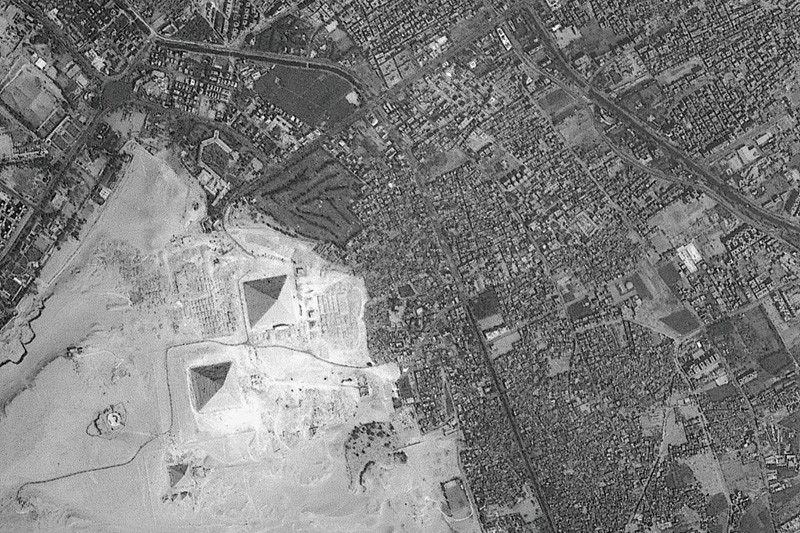
Development encroaches on the pyramids at Giza.Credit: ESA
The economies of many developing countries are rural, with agriculture accounting for more than 25% of gross domestic product. Often, more than 40% of a developing country’s workforce is involved in farming. Food supplies can be unreliable.
Natural hazards are another threat. Belt and Road nations experience about 85% of the world’s major earthquakes, tsunamis, typhoons, floods, droughts and heatwaves. For example, more than 86,000 people were killed or reported as missing in a massive earthquake in Wenchuan, China, in May 2008. And the 2004 Indian Ocean earthquake and tsunami killed hundreds of thousands of people. Seven of the top ten countries that saw major losses from disasters between 1995 and 2014 are in this region.
If we do nothing, sensitive environments will be lost and exposure to risks will rise.
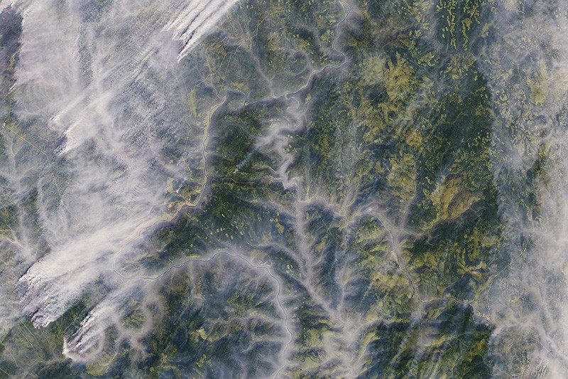
Wildfires threaten boreal forests in Russia.Credit: ESA
To address these problems, a combination of accurate, reliable and timely scientific observations of the state of terrestrial and marine ecosystems is essential — from space, the air and on the ground. However, coverage and infrastructure are poor. Many countries cannot afford to train experts in Earth-observing techniques or install ground stations to monitor soil nutrients or air quality. For example, Kyrgyzstan, Tajikistan, Turkmenistan and Uzbekistan have no Earth-observing satellites or facilities for mass data processing. Local data are rarely shared and are often locked away in government or university archives.
I chair the Digital Belt and Road Program (DBAR) initiated in 2016 by Chinese scientists in cooperation with experts from 19 countries and 7 international organizations. Our aim is to improve environmental monitoring, promote data sharing and support policymaking using big data on Earth observations. The Chinese Academy of Sciences (CAS) is investing more than 200 million yuan (US$32 million) in the next 5 years to support DBAR.
The programme will monitor different types of ecosystem and their evolution, including grasslands, forests, glaciers, urban areas, farmland and coastal regions. Environmental and socio-economic information will be shared through a platform for big Earth data, scheduled for roll-out between 2016 and 2026. This open-access gateway will allow researchers, policymakers and the public to track changes, development and trends. The programme will investigate indices and indicators to feed into the UN’s 2030 Sustainable Development Goals.
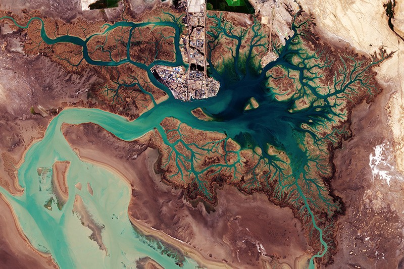
Musa Bay in Iran faces ecological damage from shipping.Credit: ESA
There are four main obstacles to a strategy on big Earth data for the Belt and Road region: poor access to data; a digital divide between developed and developing countries; a lack of awareness among some policymakers, local scientists and practitioners of the potential of Earth observations; and too little collaboration. These are long-standing problems — they also slowed emergency responses during and after the Indian Ocean tsunami in 2004, for example.
DBAR’s main approach is to work towards a platform that can handle a wide variety of information. Data sets and infrastructure are being assembled, and services should start to become available by the end of 2018. Eight key challenges are being targeted: adapting to climate and environmental change; mitigating disaster risk; managing water supplies; increasing agriculture and food security; protecting natural and cultural heritage; sustainable development of urban areas and infrastructure; managing coasts and marine areas; and understanding changes in high mountains and the Arctic.
For example, in agriculture, the main difficulty faced by most food-insecure countries of the region is a lack of up-to-date information about the supplies, yields and management of crops. DBAR is expanding the cloud-computing-based system CropWatch for monitoring and managing the availability of maize (corn), rice, wheat and soya-bean products. Launched by CAS in 1998, CropWatch provides users from 143 countries or regions with easy access to agricultural information.
For disaster relief and risk reduction, DBAR is developing a platform for sharing Earth-observation imagery. The value of such information in quickly assessing the impacts of extreme events has been proved in China and developed countries, and needs to be opened to others. For example, following the 2008 Wenchuan earthquake, Chinese rescuers were alerted to 700 people trapped in a village after seeing aerial imagery of “SOS700” written on top of a building.
The processes that shape urbanization need to be understood. Earth observations can reveal trends in the growth of cities and help planners to overcome traffic congestion, energy shortages, urban sprawl and poor basic services. For example, DBAR scientists are modelling the growth of Moscow to inform development in Beijing. The programme is also monitoring the impacts of some big infrastructure projects, including the Mombasa–Nairobi Standard Gauge Railway, Colombo Port City and the Malaysia–China Kuantan Industrial Park.
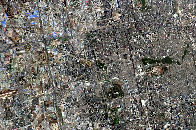
Beijing’s urban development can be tracked from space.Credit: ESA
The entire landscapes of World Heritage Sites — including human influences — need to be protected, not just their monuments2. For example, at Angkor in Cambodia, Earth observations that included airborne laser scans revealed the remains of multiple cities aged 900 to 1,400 years old lying beneath the tropical forest floor3. Deforestation and urban sprawl are the main risks that should inform a broader management strategy.
Way forward
We plan to focus on five priority areas at DBAR.
Enhance infrastructure. An open platform with shared data, codes and algorithms is urgently needed for analysing the vast amounts of Earth-observation data, which are already daunting and will only increase. The European Space Agency’s Sentinel-5P satellite, launched in October 2017, takes 20 million observations of air pollutants and gases each day — 10 times more than previous missions. Cloud computing must therefore be core4. It would currently take 1,200 years for one computer to process 3 million planetary-scale satellite scenes; a cloud-computing facility could do it in 45 days5. Earth-observing satellite data from upcoming missions will need to be incorporated.
Promote data sharing and interoperability. Data need to be openly exchanged if everyone in the region is to benefit. This will require decisions about suitable formats, information and support for handling them, as well as methodologies and tools to maximize exploitation of the data.
Extend applications to more people. Development across the Belt and Road region is uneven. To close these gaps, it is necessary to improve common solutions provided by big Earth data6. Access to tools such as CropWatch needs to be extended. Use of the digital cloud can allow anyone to access services anywhere across the region, and to accelerate the development of applications for various users.
Identify research opportunities. Knowledge could be discovered within the huge multidisciplinary data sets. For example, studying changes in the land surface of the Yellow River Delta from space over the past 40 years has increased our understanding of how its evolution depends on land use, precipitation and water flows. Researchers must help to raise awareness of the scientific potential and solutions provided by big Earth data, especially in less-developed countries.
To help bridge the technical divides between richer and poorer nations, DBAR should set up joint programmes, laboratories and international centres of excellence for gathering experts from participating countries. The programme has already established eight centres of excellence, in Pakistan, Thailand, Finland, Italy, Russia, Morocco, Zambia and the United States.
DBAR has embarked on an ambitious journey to build a digital Silk Road for sustainable development — we invite even more natural and social scientists to join this shared endeavour.
Via TechCrunch, an interesting report on how one organization is using augemented reality, gamification, and mapping to help improve conservation outcomes:
Wildlife conservation groups have made a lot of strides in raising awareness of animals whose populations or natural habitats are endangered, and what we can do to help. Now a startup out of Kenya is tapping into advances made in augmented reality, mapping and app-based games to further the cause.
Internet of Elephants, a startup based out of Nairobi, is building an app-based game of the same name that lets users learn more about different species of wildlife in Kenya, as well as other countries and regions, by letting users select the animals and “place” them into their real-world environments to follow them around. Users can learn more about the animals through a reference guide in the app, as well as by walking around the physical world and playing games based on the migratory paths of each creature.
Internet of Elephants (a pun on “Internet of Everything”) brings together and tips its hat at a number of innovations in the worlds of mobile and gaming. Niantic’s Pokemon Go has catapulted augmented reality gaming into the mainstream with its premise of finding and “catching” of fictional Pokemon creatures, using the screen on your handset projecting them into your surroundings in real time. Apple and Google have also laid the groundwork for significantly more apps using AR in their feature-set with the respective launches of ARKit and ARCore.
Beyond Pokemon Go, there is a wider group of games that also rely on location and mapping technology built into our devices as part and parcel of the experience, from Zombies, Run! through to the very legacy game of Geocaching (which has actually been around since 2000, played first on GPS devices).
Equally important is that wildlife organizations, like many others, have capitalised on the app revolution both to create content about their work and disseminate it. Many today take it for granted that we can find whatever information we want simply by tapping our little screens, but similarly, now those who have the information know that this is now an essential way to communicate with the wider world, and apps that take you beyond basic reference are the most effective at doing that.
Internet of Elephants brings all of these strands together in its effort to educate consumers about wildlife, and to do so in a more engaging way.
The product is the brainchild of Gautam Shah, an American who came to Kenya originally working in IT consultancy for a large firm. Feeling the pull to start something of his own, and a wildlife enthusiast, he could see the opportunity to build a new business from the ground up to address these two things while also leveraging a rising tech ecosystem in the city.
As TechCrunch saw in our own trip to Nairobi earlier this year, where we organised our first regional Battlefield event independent of a Disrupt conference, the city is one of the thriving hotspots for tech entrepreneurship in sub-Saharan Africa.
Innovations like M-Pesa, the highly successful mobile payment service that acts as a bank account and payment method for those who either do not have a traditional bank account or payment card, got its start in Kenya. Even more than that, it has now become one of the key examples of how sub-Saharan Africa — one of the more underdeveloped regions in the world — is ripe for some of the newest and most interesting innovations hitting the market today to fill the vacuum and help improve people’s lives.
Anchored by Shah, the full team is a mix of Nairobi natives coupled with expats who have moved to the city through past work, as Nairobi is also a popular place from which development and humanitarian organizations run operations. They include some very interesting folks: the product lead, Jake Manion, had spent six years as the creative director for Aardman Animations, the Academy-award winning studio behind Wallace & Gromit and Shaun the Sheep; and the startup has not just a team of technical and product people working on different elements of the game, but another group focused on the content, and specifically how it interfaces with the wider wildlife conservation community.
The conservation community is where Internet of Elephant’s business model comes into play. The company today building its animal kingdom (so to speak) out by way of partnerships with different groups, who can essentially create their own areas within the app, where they help build up the material related to a particular animal, either in terms of those migratory patterns or other background information.
Over time, the idea will be to cover various geographies and different groups, as well as other kinds of organizations that work with animals, such as conservation-minded zoos and preserves.
As with many other mobile games, there are a number of features built in that Internet of Elephants could potentially monetize, both for its own business as well as on behalf of these organizations, such as new levels and migrations, or new animals to unlock, and of course options to donate within the app.
I had a chance to talk to Shah at the Nairobi National Park, a wildlife park just next to the city with the skyline surreally visible at the horizon of the savannah. That juxaposition seemed to make for a fitting location to talk about how Internet of Elephants is using tech to shed more light onto a very non-tech part of our world.
,
Read More » Posted in Blog | Comments Off on Internet of Elephants
New technical innovations such as location-tracking devices, GPS and satellite communications, remote sensors, laser-imaging technologies, light detection and ranging” (LIDAR) sensing, high-resolution satellite imagery, digital mapping, advanced statistical analytical software and even biotechnology and synthetic biology are revolutionizing conservation in two key ways: first, by revealing the state of our world in unprecedented detail; and, second, by making available more data to more people in more places. The mission of this blog is to track these technical innovations that may give conservation the chance – for the first time – to keep up with, and even get ahead of, the planet’s most intractable environmental challenges. It will also examine the unintended consequences and moral hazards that the use of these new tools may cause.Read More