
Via The Conversation, a look at how blockchain is strengthening tuna traceability to combat illegal fishing:
In a significant development for global fisheries, blockchain technology is now being used to improve tuna traceability to help stop illegal and unsustainable fishing practices in the Pacific Islands tuna industry.
The World Wildlife Fund (WWF) in Australia, Fiji and New Zealand, in partnership with US-based tech innovator ConsenSys, tech implementer TraSeable and tuna fishing and processing company Sea Quest Fiji Ltd, has just launched a pilot project in the Pacific Islands tuna industry that will use blockchain technology to track the journey of tuna from “bait to plate”.
The aim is to help stop illegal, unreported and unregulated fishing and human rights abuses in the tuna industry. These have included reports of corruption, illegal trafficking and human slavery on tuna fishing boats.
It is hoped the use of blockchain technology will strengthen transparency and enable full traceability, thereby countering significant threats to licensing revenue and crew working conditions and safety, and broader impacts on the environment.
Blockchain is evolving beyond Bitcoin
Blockchain technology is rapidly evolving beyond Bitcoin. Emerging applications are geared to improve business in many ways – including supply-chain transparency for all kinds of products.
A blockchain is a digital ledger that is distributed, decentralised, verifiable and irreversible. It can be used to record transactions of almost anything of value.
Essentially, it is a shared (not copied) database that everyone in the network can see and update. This system provides multiple benefits for supply chains, including high levels of transparency. This is because everyone in the network can see and verify the ledger, and no individual can alter or delete the history of transactions.
For consumers, this means you will be able to scan a code on an item you want to buy and find out exactly where it has been before landing in your hands. It will be easy to answer those tricky questions about whether or not an item – such as a fish – is sustainable, ethical or legal.
Using blockchain to trace tuna
The WWF pilot project will use a combination of radio-frequency identification (RFID) tags, quick response (QR) code tags and scanning devices to collect information about the journey of a tuna at various points along the supply chain. While this use of technology is not newfor supply-chain tracking, the exciting part is that the collected information will then be recorded using blockchain technology.
Tracking will start as soon as the tuna is caught. Once a fish is landed, it will be attached with a reusable RFID tag on the vessel. Devices fitted on the vessel, at the dock and in the processing factory will then detect the tags and automatically upload information to the blockchain.
Once the fish has been processed, the reusable RFID tag will be switched for a cheaper QR code tag, which will be attached to the product packaging. The unique QR code will be linked to the blockchain record associated with the particular fish and its original RFID tag. The QR code tag will be used to trace the rest of the journey of the fish to the consumer.
At the moment, linking tags is not difficult because the project is focusing on whole round exports – that is, the whole fresh fish minus head, gills and guts. It gets a little more complicated when the fish is cut up into loins, steaks, cubes and cans, but the project team is now able to link the QR code tags on the packages of the processed fish with the record of the original fish on the blockchain.
While it may be possible to use RFID tags throughout the whole process, the expense of these tags could prohibit smaller operators in the fishing industry from participating in the scheme if it expands. There is also potential to use near field communicator (NFC) devices to track the fish all the way to the consumer in the future.
Bringing much-needed transparency to the industry
While this use of the blockchain is the first of its kind for the Pacific Islands region, it is not a world first. A company called Provenence and the International Pole and Line Association (IPLA) has already completed a successful pilot project tracing products from Indonesian tuna fisheries to consumers in the UK.
Provenance is also working on using blockchain to track a range of other physical things – including cotton, fashion, coffee and organically farmed food products. However, the potential of blockchain goes further. For example, Kodak recently launched its own cryptocurrency to help photographers track and protect their digital intellectual property.
Blockchain technology is just starting to change the way business is done. If it delivers on its promise of supply-chain transparency, it will be a great tool to help ensure that industries – including the tuna industry – are doing the right thing.
This will give consumers more information on which to base their purchasing decisions. For the global tuna industry, which has historically struggled with illegal and environmentally dubious fishing practices, this could be a turning point as visionary fishing companies demonstrate true stewardship and begin to open up the industry to full transparency.
,
Read More »Via Conservify, interesting commentary about their open conservation movement:
Throughout the general discussion around open source, one subject that is not generally mentioned is wildlife conservation. But, as with many things that are new or not-yet-discussed, that doesn’t mean that it doesn’t have a place in there. Open conservation is the where my work is focused, with the hope that we can lower the costs and barriers associated with effective conservation through the use of open source technologies.
I was recently on episode 24 of the OKCast podcast talking about Open Conservation. The OKCast is a weekly open source blog and podcast with “the goal to explore, connect, use and inspire open knowledge projects around the world to develop the public commons, improve organization and government transparency and communication, and advocate for social justice and social activism.” You should certainly listen to some of their previous podcast and follow them on Twitter.
Openness is at the very core of Conservify, since our current closed information management approach and sole reliance on military enforcement are the root causes why we are too slow and expensive to stop wildlife crime. These closed systems mask the true size of the wildlife problem. Communities and nonprofits are begging for these types of solutions and there currently exists almost nothing out there. When conservation information changes from something that only a few can access to an open public good, then the incentives around wildlife crime and overexploitation start to change for the better.
Open source methods have been used in every one of my conservation technology research projects and pilot implementations to date, including a dedication to share developed code on open repositories with open licenses. Arduino-based hardware sits at the core of the ultraVMS prototypes. MPA Guardian was built using Ushahidi and FrontlineSMS. SoarOcean was built through the DIY Drones community and all the associated hardware, tools, flight plans, documentation, and lessons learned will be freely shared on the Conservify and SoarOcean websites. The connected conservation sensor platforms all make use of Arduino or Raspberry Pi devices to manage the sensors with code available on the Conservify repositories. All data from these projects are published with Open Data licenses to allow access and reuse of the sensor readings.
Additionally, the work with the National Geographic funded Okavango Wilderness Project seeks to fundamentally open up the way scientific field expeditions are conducted. In 2014, a team of National Geographic Explorers (including myself) traveled along the Okavango Delta in Botswana, sharing every piece of data we collected including environmental readings, water quality, wildlife sightings, biometrics, and more to any researcher, citizen scientist, artist, student, or interested person that wanted it (through access to the IntoTheOkavango.org API). This is revolutionary because, in the past scientists would go on expeditions and collect data, just to closely guard the data until they can publish it and gain accolades. We were seeking to do exactly the opposite. I am the project technologist and open hardware designer, focused on water and air quality testing and building of prototype environmental monitoring stations based off the Raspberry Pi. For the 2015 expedition, I am building a mesh network of open source environmental sensors to help us measure, in real time, the heartbeat and health of this critical habitat. We are equipping the expedition canoes (mokoros) with connected conservation devices to map environmental data as the three-month expedition travels from the source of the delta in Angola, through Namibia, and into Botswana. The open source hardware and software used for this are part of the baseline that Conservify is built upon.
Conservify’s mission is to seek openness as a means of battling environmental crimes and providing mechanisms for increased cooperation in conservation. Through better management, analysis, and geospatial visualization of this data, we can showcase successes, share challenges, and create a comprehensive global understanding of the health of our ecosystems. Through creating information where there was none before, we can shift the incentive structures around wildlife trafficking and coordinate action around an issue. By listening to the communities most impacted by overfishing and poaching, I realized that we needed to create an open and free way for a concerned citizen, NGO, community, government, academic, or scientist to be able to establish a conservation project and help to collect the data to make the protection of these resources successful. We now have the tools to keep wildlife reserves free from poaching, illegal logging, and pollution by modernizing and opening up the technology to do so.
,
Read More »Via Yale’s e360, a report on how – while the rapid growth of digital data has been a boon to researchers and conservationists – experts are now warning of a dark side: Poachers can use computers and smartphones to pinpoint the locations of rare and endangered species and then go nab them:
Melita Weideman, then a Knersvlakte ranger, had just finished work one July afternoon in 2015 when she was called to check out a mysterious pickup truck parked just outside the reserve. Weideman saw a man and woman walking through the approaching winter sunset toward the vehicle and then noticed empty cardboard boxes on the double-cab’s back seat. “That’s very weird,” she recalls thinking. “It looks like they’re collecting things.”
The couple had no reserve entry permits. When Weideman asked to see inside their backpacks, they initially refused. “It was quite a stressful situation because we [rangers] are not armed, and I didn’t know if they were armed.” But Weideman persisted and the bags were opened, revealing 49 of the the small, cryptic succulent plants that grow between the Knersvlakte’s stones. Jose (aka Josep) Maria Aurell Cardona and his wife Maria Jose Gonzalez Puicarbo, both Spanish citizens, were arrested. A search of their guesthouse room in a nearby town revealed 14 large boxes containing over 2,000 succulents, including hundreds of specimens of threatened and protected species, courier receipts showing that many more had already been sent to Spain, and notes documenting their extensive collecting trips across South Africa and neighboring Namibia.

The succulent species Argyroderma theartii, found in the Knersvlakte reserve in South Africa.
Authorities soon discovered that the couple had been selling poached plants through their anonymously-operated website, www.africansucculents.eu, and calculated the value of the plants in their possession at about $80,000. After 16 nights in nearby jails, Cardona and Puicarbo accepted a plea bargain, paid a $160,000 fine — the largest ever for plant thieves in South Africa — and were banned from the country forever.
Cardona and Puicarbo’s ill-fated trip had been meticulously planned using information sourced online. They were carrying extracts from data lists and books about threatened plants, electronic scientific journals describing new species, messages from botanical listservs and social networks, pages from a digital archive of museum specimens named JSTOR Global Plants, photos and information from citizen science website iSpot, detailed maps from off-road vehicle websites, and hundreds of tabulated GPS waypoints for rare plant locations apparently downloaded from the Internet.
Twenty or more years ago it would have taken dozens of long field trips and thousands of miles of travel to acquire this volume of detailed information about southern Africa’s rare succulents; an entire botanical career, perhaps. In 2015, a pair of poachers could acquire it in a short time from a desk on another continent.
The Cardona-Puicarbo case provides rare insight into an emerging problem: The burgeoning pools of digital data from electronic tags, online scientific publications, “citizen science” databases and the like – which have been an extraordinary boon to researchers and conservationists – can easily be misused by poachers and illegal collectors. Although a handful of scientists have recently raised concerns about it, the problem is so far poorly understood.
Today, researchers are surveilling everything from blue whales to honeybees with remote cameras and electronic tags. While this has had real benefits for conservation, some attempts to use real-time location data in order to harm animals have become known: Hunters have shared tips on how to use VHF radio signals from Yellowstone National Park wolves’ research collars to locate the animals. (Although many collared wolves that roamed outside the park have been killed, no hunter has actually been caught tracking tag signals.) In 2013, hackers in India apparently successfully accessed tiger satellite-tag data, but wildlife authorities quickly increased security and no tigers seem to have been harmed as a result. Western Australian government agents used a boat-mounted acoustic tag detector to hunt tagged white sharks in 2015. (At least one shark was killed, but it was not confirmed whether it was tagged). Canada’s Banff National Park last year banned VHF radio receivers after photographers were suspected of harassing tagged animals.
While there is no proof yet of a widespread problem, experts say it is often in researchers’ and equipment manufacturers’ interests to underreport abuse. Biologist Steven Cooke of Carleton University in Canada lead-authored a paper this year cautioning that the “failure to adopt more proactive thinking about the unintended consequences of electronic tagging could lead to malicious exploitation and disturbance of the very organisms researchers hope to understand and conserve.” The paper warned that non-scientists could easily buy tags and receivers to poach animals and disrupt scientific studies, noting that “although telemetry terrorism may seem far-fetched, some fringe groups and industry players may have incentives for doing so.”
It is difficult to tap into most tag data streams, say experts. Accessing an unencrypted VHF signal from a relatively cheap radio tag requires knowledge of its exact frequency, although this can sometimes be found with a scanner. Data from more-expensive GPS tags are usually encrypted and password-protected. “I’m not saying it’s impossible to hack into a tag signal,” says one African technical expert who declined to be named because he sells GPS tags for rhinos and elephants, “but you would need extremely high-level knowledge and equipment. I don’t know of any cases in Africa.”
A more serious risk, experts say, is posed by the voluminous geospatial information in Internet-accessible databases like those being created by museum staffers who are archiving millions of digital photos of plants and animal specimens, each with a location attached. In addition, huge “citizen science” projects are leveraging millions of volunteer hours to build species databases bulging with geospatial datapoints and geo-referenced photographs, audio, and videos.
These data stores of species’ locations are an irreplaceable and growing asset to science and conservation, enabling researchers to pinpoint threats to endangered species, observe ecosystem responses to climate change, and even uncover new species. Many are designed to be open and easily accessible, which has multiplied their value and dramatically lowered research costs.

Geotagged bird sightings in northern India, mapped by the citizen science website eBird.
eBird, based at Cornell University, is one of the world’s most successful “citizen science” wildlife mapping projects. It has a quarter of a million registered users globally who have uploaded hundreds of millions of observations from almost every country. By “gameifying” birding to leverage birders’ competitive instincts, eBird has built a highly productive community of volunteer data collectors who have enabled scientists to identify threats to birds and understand bird movement in unprecedented ways.
Like many other citizen science projects, eBird was deliberately developed to encourage data sharing. Contributors can share and download lists of bird locations and find millions of sightings on digital maps. It’s so open, says project leader Marshall Iliff, that “anyone can basically download the entire eBird dataset.”
When eBird launched, Iliff says, the idea that its data could be used to harm birds was far from its developers’ minds, because few North American species are seriously threatened by illegal hunting or capture. As the project has expanded into countries where more birds are threatened by such activities, however, staff have realized that some species’ data should be hidden. But this is no simple task: Since eBird’s edifice was built from the ground up to be maximally accessible, Iliff says, hiding data is “a challenging thing to work out both on the technical and the policy sides.” After much deliberation, the platform’s code is now being extensively rewritten so selected species’ locations can be kept from public view.
While few North American birds may be endangered by releasing their geospatial data, this is not true for many small, lesser-known species in the developing world. A shadowy international community of collectors pays well for rare succulent plants, orchids, reptiles, spiders, and insects, often found where wildlife law enforcement is patchy. The more obscure and rare a species is, the more valuable. Rarity makes species vulnerable to being completely wiped out by poachers; some targeted South African plants and insects are found only in a few acres.
Paul Gildenhuys, who heads the biodiversity crime unit in South Africa’s Western Cape Province, tells me that in the past, many poachers were academics looking for a few specimens for themselves. Now more profit-focused international traders have entered the scene, he says, “and they really don’t care. If they find a lizard colony, they won’t just take one or two animals, they’ll bring crowbars to smash rocks so they can take the whole lot.”
Collectors scour scientific journals for descriptions of new species, which traditionally include their locations. Many new species have been poached within months of being described, which recently inspired David Lindenmayer and Ben Scheele of the Australian National University to write a strongly worded article in Science titled “Do not publish.” Pointing out that academic journals are rapidly embracing online open-access publication, they called on their colleagues to “urgently unlearn parts of their centuries-old publishing culture and rethink the benefits of publishing location data and habitat descriptions for rare and endangered species so as to avoid unwittingly contributing to further species declines.” In a reply titled “Publish openly but responsibly,” another group of biologists implicitly accused Lindenmayer and Scheele of overreacting, saying that existing institutional data policies were sufficient to protect species. “Conservation biologists can … ensure data are available through secure sources for approved purposes,” they wrote.
But how are “approved purposes” defined, and by whom? And which species truly require data redaction? Biologists disagree sharply. Some believe that all data from Red-Listed species should automatically be withheld; others point out that many Red-Listed species are not threatened by poachers, but by habitat destruction or climate change. Some institutions and governments currently have biodiversity data policies, but many have no policy at all. There is no internationally-agreed protocol for deciding which data to hold back and when to release it.
While biologists can control location data in their own journals and archives, they can’t control the sprawling, dynamic world of social media, where enthusiasts share wildlife notes and photos in an ever-growing galaxy of online groups. Typical of these is Snakes of South Africa, a thriving, conservation-focused Facebook group where anyone can share photos of snakes for volunteer experts to identify. The group helps find handlers to relocate snakes without harm and even assists with snakebite medical advice. Group administrator Tyrone Ping tells me that poachers often pretend to be helpful experts to learn locations of valuable snakes. “We throw them out, but they join again with a fake profile.” (I recently observed a member of a European Facebook group openly explain where to find a desired snake species in Egypt and how to smuggle it through Cairo International Airport.)

And conservation officials say tourists’ social media posts can also pose a risk. More than 1,000 rhino have been poached annually in South Africa since 2013, and a wildlife crime investigator based near Kruger National Park tells me that poachers scan social media for tourists’ photos of rhinos, which are often tagged with locations or contain identifiable landscape features. Poachers’ raids are planned with Google Maps and co-ordinated via WhatsApp. Many African parks are asking visitors not to post rhino photos, but there’s no practical way to stop them.
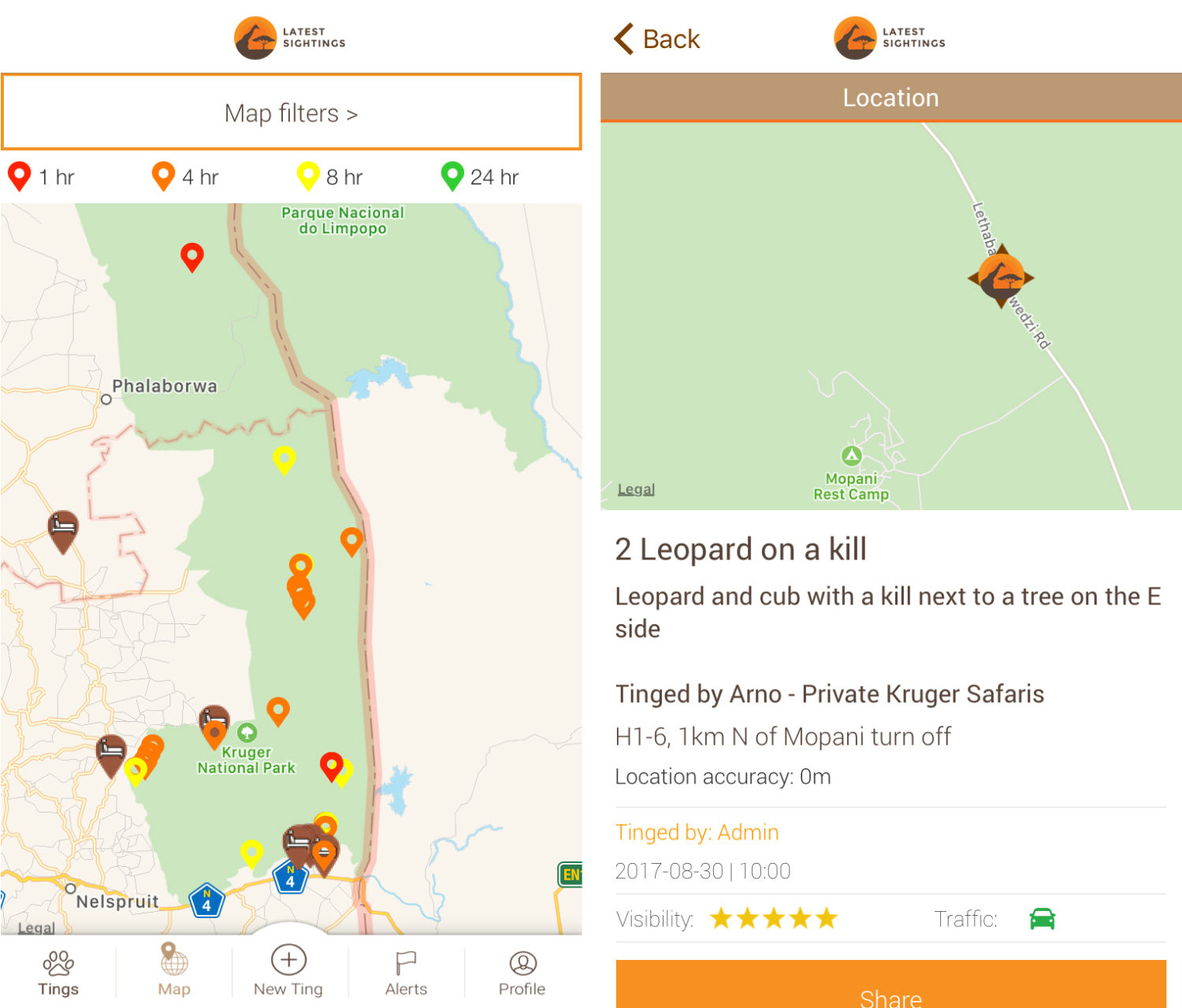
The app Latest Sightings maps real-time wildlife sightings by tourists in South Africa’s Kruger National Park
A growing number of mobile apps are designed specifically to allow tourists to share locations and photos of animal sightings with a network of fellow park visitors. Nadav Ossendryver built Latest Sightings — the most popular of these — as a 15-year-old in 2011 after a frustrating trip to Kruger National Park during which he couldn’t find “good” animals. “I kept thinking someone must be looking at a leopard or a lion, and it must be close by,” he says. Today the app has over 42,000 active members. Ossendryver tells me he’s promoting conservation to a younger audience, and his app does not log rhino sightings. But Kruger’s management is nonetheless strongly against Latest Sightings: App users, they say, are speeding toward reported sightings, sometimes road-killing animals and causing traffic congestion that interferes with natural animal behavior.
In the world of science, however, some researchers remain wary of moves to withhold data. “Science depends on the transparency of information,” says Vincent Smith, a research leader in informatics at London’s Natural History Museum. “Geospatial information is some of the most valuable data we have. To remove it would remove the opportunity to do enormous amounts of research. It would seriously harm all science.”
Tony Rebelo, a South African biologist and supporter of iSpot, a crowd-sourced online archive, says that to some extent policies on withholding information are irrelevant because “once you give your data to anyone, no matter how trusted, it’s out there.” It’s also hard to track and predict the fickle collectors’ market. A species can suddenly become desired years after its location has been deemed safe to publish. Many researchers I interviewed had been contacted by fake biologists seeking data on rare species.
One case bolsters the claim that hiding geospatial data can protect species. In 2009, Tim Davenport, the Wildlife Conservation Society’s program director in Tanzania, discovered an attractive new snake species in a small forest in that country. He named it Matilda’s Horned Viper, Atheris matildae, after his daughter. Recognizing that its tiny natural range made it vulnerable to poachers, he formally described it in 2011 without publishing its location, which was unusual at that time. Davenport says that although he has seen Atheris matildae advertised online, every case he has followed up involves a seller passing off a similar, common species. Hiding its locality seems to have worked.
,
Read More »Via GreenBiz, a look at how satellite imagery is transforming conservation science:
As recently as the 1980s, gray seals effectively were extinct on Cape Cod. So when researchers announced last week that the population there has recovered not to 15,000 gray seals, the previous official estimate, but to as many as 50,000, it was dramatic evidence of how quickly conservation sometimes can work.
But the researchers, writing in the journal BioScience, weren’t just interested in the seals. They also sought to demonstrate the rapidly evolving potential of satellites to count and monitor wildlife populations and to answer big questions about the natural world. That’s still news to many wildlife ecologists, according to senior author David W. Johnston, of Duke University’s Nicholas School of the Environment. Ecologists have been slow to incorporate satellite data in their work so far, in part because their training and culture are about going into the field to get to know their study subjects first hand. The perspective from outer space has not necessarily seemed all that relevant.
But the rapidly growing abundance and sophistication of satellite imagery and remote sensing data is about to change that: “High-resolution earth imagery sources represent rich, underutilized troves of information about marine and terrestrial wildlife populations,” Johnston and his co-authors write. They urge wildlife ecologists to embrace satellite imagery “as a legitimate data source that can supplement and even supplant traditional methods.”
Among other promising developments, they note, satellite imagery of the Earth is being collected “globally, frequently, and at increasingly relevant resolution.” It’s also becoming available in user-friendly formats thanks to a profusion of startup companies, including Planet, DigitalGlobe, Skybox Imaging (later purchased by Google and renamed Terra Bella), Urthecast and LAND INFO Worldwide Mapping.
In February, for instance, Planet deployed 88 breadloaf-size satellites from an Indian Space Research Organisation rocket. They are now part of a 149-satellite constellation scanning every point on Earth several times a week. The primary focus is on commercial applications — for instance, tracking corn yields in Iowa, or how many cars are parked in the Walmart lot today. But the image frequency also has begun to enable rapid detection of deforestation, illegal mining and other changes in the landscape, as well as more efficient and accurate counting of wildlife populations.
NASA is also part of this trend. In 2019, it plans to launch a mission called GEDI (the Global Ecosystem Dynamics Investigation) using lidar, a laser-based remote sensing technology already familiar to ecologists for mapping 3-D vegetation structure from airplanes. This time, from the International Space Station, GEDI will enable scientists to determine the height and structure of the forest in any given location and precisely map aboveground biomass and carbon storage — all without applying for grants to hire an airplane or spending days flying transects.
GEDI also will make it possible, according to the University of Maryland’s Ralph Dubayah, principal investigator on the mission, “to estimate the net impact of deforestation and subsequent regrowth of forests, and to provide information critical for preserving and promoting habitat quality and biodiversity.” The technology should prove useful for monitoring commitments made by nations under REDD (the program to reduce emissions from deforestation and forest degradation) as well as under the Paris climate accord and the Convention on Biological Diversity. In addition, it will improve weather and climate modeling and provide detailed measurement of temperate glaciers, lakes and rivers for better management of water resources.
Ecologists “are going to have this epiphany,” said Johnston, as they begin to understand the potential of these new tools. It happened for him a few years ago while giving an undergraduate lecture about the movements of radio-tagged seals on Cape Cod. “We have tags on live animals, and it’s really great for students,” he said. “They can check in every day on where a particular seal is traveling. I was loading data on Google Earth, and just zoomed right in to see where this seal turned up, and lo and behold, the image was good enough to count seals on the beach. I looked and said, ‘Hey, we could probably count the Cape Cod seal population this way,’ and at the end of class, three students came up to say they’d like to do that.”
The seals commonly use beaches as summertime “haul-outs,” and in the past, the National Oceanic and Atmospheric Administration (NOAA) has counted them in the traditional fashion, by flying over the beach and taking photographs. But NOAA never got around to publishing all the resulting data, to the frustration of other researchers, said Johnston, and it also “never worked to correct the beach count for the number of animals at sea.”
Satellite images freed the researchers from dependence on the NOAA data. And data from their own long-term radio-tagging study, showing how much time seals spend typically at sea in a given day or season, allowed the researchers to develop an algorithm for calculating the total population, rather than just the part visible on the beach.
Douglas McCauley, a marine biologist at the University of California Santa Barbara, praises the new study for bringing the potential of satellite-based wildlife research “home to our own backyards,” on a question with major management implications. For Cape Cod vacationers feeling that a seal haul-out has crowded them off a favorite beach, or for fishermen losing their catch to seals, news that 50,000 gray seals are now on the Cape is likely to sound like an invasion.
For conservationists, on the other hand, it may not even represent recovery to the original population level. The long-running debate about the seals can become highly emotional. An accurate count is the essential starting point for deciding among such management options as keeping hands off, paying for a contraceptive darting program, authorizing nonlethal harassment or even beginning to cull seals. “This is placing satellite data front and center in wildlife management,” said McCauley.
Beyond counting populations, satellites also have the potential to answer bigger wildlife behavioral questions. McCauley’s lab is using satellite data, for instance, to determine how wildebeests in the Serengeti exploit the habitat. “You can take one satellite image and you can sense the productivity — where the grass is greenest — based on reflectance patterns. And you can create a layer showing where all the wildebeests are, and see if they are tracking the productivity of the environment well.”
Another overlay factors in the “landscape of risk,” he said — a predator attack is more likely on the edge of a forest, or near one of the rock outcrops called kopjes, or at a watering hole. “Then you can ask how all that maps onto the migration corridor” to understand the importance of protected areas, especially in the face of increasing human development. Over the years, McCauley’s team and collaborators at the University of Glasgow have tracked several dozen wildebeests using radio collars. “This year, we don’t want to track two more,” he said. “We want to track 200,000” via satellite.
McCauley describes the rapidly improving view from outer space as “a macroscope.” It also should be a major boost for dwindling conservation program budgets, because the data is often available at no cost — and at much less risk for the researchers. In a study of U.S. biologists killed during research or management work from 1937 to 2000, two-thirds died as a result of air accidents.
“I don’t think we are ever going to get away from people in airplanes doing some biology,” said Johnston. “But for things that are especially dangerous, like over the water,” or in remote polar regions, satellite images are at least as good.
So why haven’t more wildlife researchers rushed to take advantage of satellite data? Partly because of scientific fiefdoms, said Nathalie Pettorelli of the Zoological Society of London: “Biological tradition is built on going outside and working with species. But the development of remote sensors and the use of satellite data have mainly happened in geography departments. Those two disciplines haven’t been used to working together. They don’t share common terminologies. A remote sensing expert will tell you about land cover, and a biologist will tell you about ecosystems. So you have to reconcile those viewpoints.”
When Pettorelli first turned to satellite data to help determine how environmental change is affecting biodiversity and ecosystem services, biologists told her it was a bad idea. “There are people who don’t trust satellite data,” she said. They consider it “competition with ground data,” although in reality satellite and ground data often enhance each other, as happened with the Cape Cod seals. Meanwhile, the remote sensing experts “were telling me it’s too complex; you need to hire somebody. I didn’t have money to hire somebody, and I just learned more and more how to do it myself.”
Lack of training remains an obstacle to broader reliance on satellite data, she says, “particularly in developing countries where people could get the most out of it, where there is no money for large on-the-ground studies,” or for airplane surveys. “But for the moment a lot of biologists have no idea what remote sensing is, how to get the data, how to use the data.”
That lack of familiarity with the nuances of satellite data is also an impediment at the global level, said Pettorelli. Under the Convention on Biological Diversity, the 196 party nations have a series of targets to achieve by 2020 for the conservation of protected areas and the protection of plant and wildlife diversity. The only way to monitor progress in a timely and economical way is by satellite, said Pettorelli. But with just three years to go, participants still haven’t even agreed on which space-based indicators to rely on. Building trust in satellite data among her fellow biologists remains a painfully slow process.
,
Read More »Via Third Pole, a look at how – using data from NASA – Pakistan’s water research agency is sending rain forecasts to 10,000 farmers, helping them to irrigate more efficiently and increase their crop yields:
It is still beyond farmer Mohammad Ashraf’s comprehension that people in Islamabad can predict that it will rain in the next two days in his village. He is also astonished that, based on this prediction, they can tell him how much he should water his rice and sugarcane plantations.
“I marvel at this science of being able to predict something that is unknown and in God’s hands,” says the 36-year-old farmer, Every Friday, he reads the simple Urdu messages sent to his phone, saying things like: “Dear farmer friend, this is to inform you that between 21 and 28 July 2017 in your area (Bahawalnagar) the crops used this much water (cotton 1.6 inch, sugarcane 1.7 inch). Next week, rain is predicted in some parts of your region. Therefore please water your crops accordingly.”
The text messages (or SMS) are sent by the Pakistan Council of Research in Water Resources (PCRWR), a government agency that carries out water research. Ashraf would be even more flabbergasted if he knew the scientists get this information from space.
“Using satellites and models that take the pulse of the earth, we can identify the amount of water a given crop requires at a specific location and a specific time,” says Faisal Hossain, head of the Sustainability, Satellites, Water, and Environment (SASWE) research group at the University of Washington which developed the programme for, “estimating crop water requirement in a cost effective and sustainable manner for the whole country”.
Ashraf, who lives in Hayatpur in Punjab’s Sargodha district, now takes these messages seriously. Five years ago, he met water experts from the PCRWR who were doing a field survey to explore how to improve groundwater conservation and crop yield. During their surveys, the experts found that farmers were over-watering their crops. They installed a water meter on Ashraf’s 12-acre farm and explained that if the arrow turned towards the green on the dial, it meant that his land had enough water. When the arrow turned towards the red mark, it was time to water.
“Like every farmer in the village, I did not believe them. We have been farming for generations and know what works and what doesn’t,” Ashraf told thethirdpole.net. But the following year, he decided to only water his field when the marker pointed towards the red. That season he produced more, spent less on diesel to run the tubewell, and made more profit than anyone in the village. “The others watered their sugarcane fields three times more than I did and not only did my plants grow taller, I had less disease in my crop than the rest.”
Ashraf says that an acre of his land yielded 1,000 maunds (1 maund = 37 kilogrammes) of sugarcane. Each maund sold for PKR 180 (USD 1.70). “I sold my crop for PKR 180,000 (USD 1,700) while most villagers could only sell between PKR 80,000 and 100,000 (USD 755-944). Now a convert, he says he plans heed to every word from PCRWR. “I’d say that 99% of the time they are right on the mark about rain,” he says.
Since last year, the PCRWR has sent weekly information to farmers like Ashraf through text messages, telling them how much water their crops need. They also send them weather forecasts.
“We started with 700 farmers in April 2016, all across Pakistan, and since January this year the number of farmers receiving the messages has increased to 10,000,” says Ahmed Zeeshan Bhatti, deputy director of PCRWR. The agency has submitted a proposal to some organisations to support it in improving the advice and expanding the service to 100,000 farmers.
“We carried out a survey to gauge the response of the farmers to our advice and the feedback was encouraging,” he says. Between 25 and 30 farmers would call back immediately for further information. “Our initial telephone survey revealed that farmers are saving almost 40% of water by rationing irrigation,” he says, adding that the service is saving around 250 million cubic metres of irrigation water per year. In the next phase of the programme, the PCRWR wants to train the farmers, as well as those working in the agriculture department, to use research and the meteorological advice properly.
“I think the information they send is quite useful for us as by conserving water, our profit margins will be greater,” says 37-year old farmer Mohammad Tariq from Faisalabad. He, however, wishes for more types of information such as when to sow, when to spray with pesticides, how many times and what seed is good for which crop.
“Currently, we are totally dependent on whatever the sellers of agri-products tell us about using pesticides and seeds. We just accept whatever they say,” he says. “If it comes from the government agency, it would be authentic.”
“When the British designed the Indus Basin Irrigation System (IBIS) between 1847 to 1947, it was to turn 67% of the basin area into farmland,” said Azeem Shah, regional researcher at Lahore based International Water Management Institute.
Even after the British left in 1947, the government irrigation engineers have been adding new dams, barrages, link and branch canals to the old system. Today IBIS has three large dams, eighty five small dams, nineteen barrages, twelve inter-river link canals, forty-five canal commands and 0.7 million tube wells. Still, say experts, canal irrigation water efficiency can be increased from the current 33% up to 90% (in the developed countries) by repairing leakages in the system, smart metering and creating effective solutions for reducing the demand for water and at the same time increasing agricultural productivity.
Further, today, said Shah, the cropping intensity has increased by 150% compared to 1947 with farmers not wanting to leave any fallow land. They also cultivate two or three crops. “Over the last 70 years, the quantity of the water has remained the same but agriculture is competing with other sectors, such as industry, as well as the growing population,” says Shah. Today, says Shah, roughly 50% of irrigation needs are met by IBIS canals and 50% is extracted from the ground.
The SMS programme is supported technically and financially by the University of Washington’s Global Affairs Department, NASA’s applied sciences programme, the Ivanhoe Foundation and the Pakistan government. When it started, the PCRWR was providing week-old information, but is now able to forecast for the present and the future. Hossain points out, however, that even if long-term forecasts were not offered, short-term weather information would still have value. “Soil moisture has memory and inertia, so knowing how much it has rained and stayed in the soil the previous week is necessary to plan the coming week’s irrigation,” he explained.
The PCRWR is able to access global weather model forecasts with the help of the University of Washington, using a Chinese model and collaborating with the Pakistan Meteorological Department. “It is thus able to provide quite accurate information,” says Bhatti.
With Pakistan among many countries vulnerable to climate change and extreme weather conditions, using scientific methods to help farmers irrigate their land more efficiently is all the more necessary. Will this advice help farmers adapt to or fend off extreme climate phenomena in the years to come?
“That’s the idea,” says Bhatti, adding that the advice should help farmers tackle climate aberrations like heatwaves, and increased frequency of heavy and intense rainfall.
Hossain is a more cautious: “The skill of general circulation model projections – say into 2040 – is poor and of little empowering value to farmers. We are more focused on providing tactical information, rather than long-term strategic information for adaptation.”
Nor is this the only cellphone-based initiative taking place in Pakistan. In the province of Punjab, the Punjab Information Technology Board (PITB) along with the Agriculture Department of Punjab, is partnering with Telenor, a cellular company providing financial services to farmers who do not have bank accounts. “Not only are we providing interest free loans to smallholder farmers we are providing them advisories on how to improve their yield by using modern agriculture practices and linking them to agriculture experts, research institutions, agriculture extension workers and input providers,” said Uzair Shahid, senior programme manager at the PITB.
Step by small step, the farmers of Pakistan may end up seeing cellphone technology as an essential part of a more productive future.
,
Read More »Via Vice’s Motherboard, an interesting look at how smart lakes and smart forests are helping researchers understand our impact on nature:

A bright yellow platform the size of a jet ski bobbed on Lake George as IBM research engineer Mike Kelly climbed aboard. Unlike the other tourists at the popular vacation spot in upstate New York, Kelly wasn’t there for a break; he was checking on sensors that transform the waterway into a “smart lake.”
The sensor rig he’d boarded was monitoring pollution, including road salt. Thick cakes of salt dumped on upper New York roads during snowstorms inevitably wash into Lake George each spring with the snowmelt, encouraging the proliferation of invasive species and making the otherwise strikingly clear waters dark and murky.
Kelly popped open a panel to show me the pulley that sends sensors into the depths of the lake. A mechanism inside was set to drop the sensors deep into the lake at the top of each hour, and reel them back in. Soon after he opened the panel, a pulley system began whirring like the spool of a mechanized fishing rod. The wire holding the sensors slid through a one-foot-wide hole in the platform’s metal grating, and I looked into the suede-blue water, wondering what types of life were getting scanned 200 feet below my soggy shoes.
Lake George isn’t the only natural spot to get a technological upgrade. Forests are also being put under the microscope to see how they develop at Harvard Forest, a sensor-laden forest monitored by Harvard University. Oregon State University analyze songbirds’ chirping, treating certain noises as a “canary in a coal mine” for larger ecological issues.
That type of technology is helpful for developed cities to better manage their natural resources, but it could be life-saving for developing regions where data on water quality is less reliable. Harry Kolar, a researcher at IBM, said the long-term vision is to sell some of these sensor units to NGOs and researchers in developing nations so they can have the data to begin addressing those problems. It will only become a bigger issue as climate change reduces the world’s available clean water.
“Managing resources such as water quality in general is becoming a bigger problem across the world and has been for a while,” he said.
At Lake George, aquatic sensors are automatically dipped into the lake every hour to take measurements, including oxygen levels, pH, and salinity. They stay on the lake throughout most of the year (except when the lake freezes over in the winter) as part of the Jefferson Project at Lake George, a research collaboration between Rensselaer Polytechnic Institute, IBM, and The FUND for Lake George.
Larry Eichler of RPI, a university in upstate New York, has been studying the lake for decades. He told me these sensors, the first of which was put on the lake in March, collect as much data in a week as he collected in 30 years of taking data by hand. Three rigs have installed 265 sensors on the lake, including one platform with sensors researchers can talk to in real-time, rather than having to pre-program. And if they pick up something interesting, such as a spike in a pollutant, they’re programmed to do additional scans automatically.
Eventually, the researchers said the sensors will be able to send an email or text message to researchers, water plant operators, and city officials in the event of a major issue, such as a toxic algae bloom or a hazardous waste spill. All of that better informs experiments—and in theory could advise local legislation.
On another rainy day in upstate New York, RPI professor Rick Relyea led me to a field full of neon-blue plastic kiddie pools and black cattle troughs. Inside the 400 or so containers were water from the lake, plus nearly every species of plant and animal that live in the lake.
This is the end stage of the smart lake experiment, part of the Jefferson Project. It collects data, modeling software predicts problems, and the kiddie pools serve as tiny lakes for experimental confirmation. “Here we can tell you what the future will be,” Relyea said.
The sensors are picking up more salt and more invasive snails? Throw that type of salt and those species into a pool with lake water and see what happens. (The calcium in one type of road salt, calcium chloride, helps invasive snails build shells easier, helping them take over.)
And if a city wants to try out a new type of road salt, they can test it here to make sure it isn’t going to cause the water to go murky or the fish to die, avoiding lost tourism dollars, crashing housing prices and boatloads of lawsuits.
As for Lake George’s future, data could protect its beauty and thriving ecosystem.
“It’s not too far gone,” Relyea said. “Changes can be made to turn it around if those changes are informed by science.”
,
Read More »


